IMAGES TAKEN NEAR TO
Felixstowe Avenue, NEWQUAY, TR7 3HN
Introduction
This page details the photographs taken nearby to Felixstowe Avenue, TR7 3HN by members of the Geograph project.
The Geograph project started in 2005 with the aim of publishing, organising and preserving representative images for every square kilometre of Great Britain, Ireland and the Isle of Man.

There are currently over 7.5m images from over14,400 individuals and you can help contribute to the project by visiting https://www.geograph.org.uk
Image Map
Images are licensed for reuse under creativecommons.org/licenses/by-sa/2.0
Notes
- Clicking on the map will re-center to the selected point.
- The higher the marker number, the further away the image location is from the centre of the postcode.
Image Listing (15 Images Found)
Images are licensed for reuse under creativecommons.org/licenses/by-sa/2.0
Image
Details
Distance
4
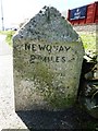
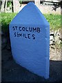
Old Milestone by the A3059, Church Street, St Columb Minor
Carved stone post by the A3059, in parish of NEWQUAY (RESTORMEL District), Church Street, St Columb Minor; by bungalow, by the road, on West side of road. Erected by the Local Highways Board in the 19th century.
Inscription reads:-
: St COLUMB / 5¼ MILES : : NEWQUAY / 2 MILES :
Carved benchmark and rivet on top.
Grade II listed.
List Entry Number: 1312187 https://historicengland.org.uk/listing/the-list/list-entry/1312187
Milestone Society National ID: CW_NQSC02.
Image: © Rosy Hanns
Taken: 12 May 2019
0.11 miles
5
Old Milestone by the A3059, Church Street, St Columb Minor
Carved stone post by the A3059, in parish of NEWQUAY (RESTORMEL District), Church Street, St Columb Minor; by bungalow, by the road, on North side of road. Erected by the Local Highways Board in the 19th century.
Inscription reads:-
: St COLUMB / 5¼ MILES : : NEWQUAY / 2 MILES :
Carved benchmark and rivet on top.
Grade II Listed. List Entry Number: 1312187
https://historicengland.org.uk/listing/the-list/list-entry/1312187
Milestone Society National ID: CW_NQSC02.
Image: © Ian Thompson
Taken: 10 Dec 2017
0.11 miles
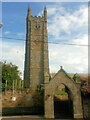
6
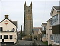
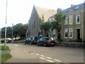
St Columb Minor Church Tower
This 115 feet high tower is the second highest in Cornwall and was built in the 15th century. The church dates from 1417 and has undergone extensive restoration on two occasions since.
Image: © Tony Atkin
Taken: 25 Feb 2006
0.16 miles
8
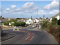
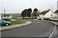
Junction at St Columb Minor
The A3059 Rialton Road (foreground) meets the A3058 at St Columb Minor. To the left, the main road is Quintrell Road; to the right, Henver Road, leading into Newquay. The footpath sign on the right indicates footpath 411/48/1, which leads through modern housing into the old village of St Columb Minor.
Image: © Derek Harper
Taken: 14 Jul 2010
0.17 miles
9

Approaching St Columb Minor
Unlike Image, this is along the A3059 Rialton Road from St Columb Major.
Image: © Derek Harper
Taken: 14 Jul 2010
0.17 miles
10

Blue Agapanthus
In a front garden in Church Street, St. Columb Minor.
Image: © Jonathan Billinger
Taken: 11 Jul 2007
0.19 miles