IMAGES TAKEN NEAR TO
Gannel Road, TR7 2FU
Introduction
This page details the photographs taken nearby to Gannel Road, TR7 2FU by members of the Geograph project.
The Geograph project started in 2005 with the aim of publishing, organising and preserving representative images for every square kilometre of Great Britain, Ireland and the Isle of Man.

There are currently over 7.5m images from over14,400 individuals and you can help contribute to the project by visiting https://www.geograph.org.uk
Image Map
Images are licensed for reuse under creativecommons.org/licenses/by-sa/2.0
Notes
- Clicking on the map will re-center to the selected point.
- The higher the marker number, the further away the image location is from the centre of the postcode.
Image Listing (40 Images Found)
Images are licensed for reuse under creativecommons.org/licenses/by-sa/2.0
Image
Details
Distance
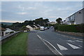
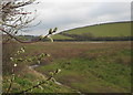
1
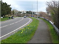
The A392 Gannel Road
The footpath alongside this road forms a stretch of the South West Coastal Path, where it follows the Gannel up to Trevemper Bridge.
Image: © Rod Allday
Taken: 27 Mar 2010
0.04 miles
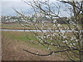
2
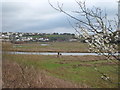
Blackthorn blossom beside the River Gannel
Looking upstream towards Treninnick.
Image: © Rod Allday
Taken: 27 Mar 2010
0.04 miles
3
Blackthorn blossom (Prunus spinosa)
One of the first true harbingers of spring - seen here beside the River Gannel.
Image: © Rod Allday
Taken: 27 Mar 2010
0.04 miles
4
'Pussy Willow' catkins (Salix caprea or Goat Willow)
Growing beside the River Gannel.
Image: © Rod Allday
Taken: 27 Mar 2010
0.05 miles