IMAGES TAKEN NEAR TO
Inner Tide Lane, NEWQUAY, TR7 2FA
Introduction
This page details the photographs taken nearby to Inner Tide Lane, TR7 2FA by members of the Geograph project.
The Geograph project started in 2005 with the aim of publishing, organising and preserving representative images for every square kilometre of Great Britain, Ireland and the Isle of Man.

There are currently over 7.5m images from over14,400 individuals and you can help contribute to the project by visiting https://www.geograph.org.uk
Image Map
Images are licensed for reuse under creativecommons.org/licenses/by-sa/2.0
Notes
- Clicking on the map will re-center to the selected point.
- The higher the marker number, the further away the image location is from the centre of the postcode.
Image Listing (6 Images Found)
Images are licensed for reuse under creativecommons.org/licenses/by-sa/2.0
Image
Details
Distance
1

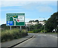
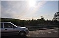
Newquay : Trevemper Road A392
A road heading into Newquay.
Image: © Lewis Clarke
Taken: 22 Oct 2019
0.09 miles
2
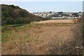
The Valley of the River Gannel
In the early 19th century this marsh was a navigable on the high tide all the way to Trevemper Bridge. In 1838 the East Wheal Rose Mine began discharging waste into the river causing a rapid increase in the silting up of the estuary.
Image: © Tony Atkin
Taken: 25 Feb 2006
0.15 miles
3
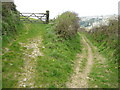
Track above the River Gannel
This track on the south side of the River Gannel is an alternative route for the South West Coast Path when the tide is high.
Image: © Philip Halling
Taken: 24 Apr 2010
0.22 miles
4
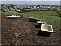
Baths near Trevemper
Probably one of Cornwall's major collections by the inland arm of the South West Coast Path between Trevemper and the crossing of the Gannel. Across the valley is the Newquay suburb of Treninnick.
Image: © Derek Harper
Taken: 3 Jul 2008
0.22 miles
5
Newquay : Side of Trevemper Road
Looking across the road with a car heading towards the centre of Newquay.
Image: © Lewis Clarke
Taken: 15 Sep 2011
0.23 miles