IMAGES TAKEN NEAR TO
Esplanade Road, NEWQUAY, TR7 1QB
Introduction
This page details the photographs taken nearby to Esplanade Road, TR7 1QB by members of the Geograph project.
The Geograph project started in 2005 with the aim of publishing, organising and preserving representative images for every square kilometre of Great Britain, Ireland and the Isle of Man.

There are currently over 7.5m images from over14,400 individuals and you can help contribute to the project by visiting https://www.geograph.org.uk
Image Map
Images are licensed for reuse under creativecommons.org/licenses/by-sa/2.0
Notes
- Clicking on the map will re-center to the selected point.
- The higher the marker number, the further away the image location is from the centre of the postcode.
Image Listing (8 Images Found)
Images are licensed for reuse under creativecommons.org/licenses/by-sa/2.0
Image
Details
Distance
1
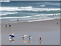
Surfing lesson, Fistral Beach
The group of students seen in Image approach the water. Seen from Esplanade Road, Pentire.
Image: © Derek Harper
Taken: 3 Jul 2008
0.15 miles
3
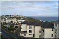
The view west from the Fistral Bay Hotel
From room 205.
Image: © David Long
Taken: 9 May 2006
0.17 miles
4
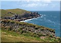
Wall and Pentire Point East
This strongly built wall is about 40 metres long. Behind, the headland juts out beyond Lewinnick Lodge.
Image: © Derek Harper
Taken: 3 Jul 2008
0.18 miles
5
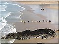
Surfers on Fistral Beach
Seen from Esplanade Road, Pentire.
Image: © Derek Harper
Taken: 3 Jul 2008
0.20 miles
6
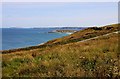
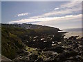
Grassland above Lewennick Cove
Towan Head is in the distance.
Image: © Steve Daniels
Taken: 14 Jun 2011
0.23 miles
7
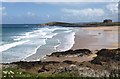
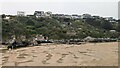
Fistral Beach
The beach seen from Esplanade Road, Pentire. Beyond is Towan Head and the Headland Hotel.
Image: © Derek Harper
Taken: 3 Jul 2008
0.23 miles