IMAGES TAKEN NEAR TO
Tower Road, NEWQUAY, TR7 1FF
Introduction
This page details the photographs taken nearby to Tower Road, TR7 1FF by members of the Geograph project.
The Geograph project started in 2005 with the aim of publishing, organising and preserving representative images for every square kilometre of Great Britain, Ireland and the Isle of Man.

There are currently over 7.5m images from over14,400 individuals and you can help contribute to the project by visiting https://www.geograph.org.uk
Image Map
Images are licensed for reuse under creativecommons.org/licenses/by-sa/2.0
Notes
- Clicking on the map will re-center to the selected point.
- The higher the marker number, the further away the image location is from the centre of the postcode.
Image Listing (27 Images Found)
Images are licensed for reuse under creativecommons.org/licenses/by-sa/2.0
Image
Details
Distance
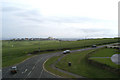
5
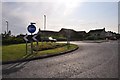
Newquay : Pentire Road Roundabout
A roundabout looking in the direction to Pentire Road.
Image: © Lewis Clarke
Taken: 15 Sep 2011
0.12 miles
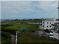
8
Newquay : Newquay Golf Club Clubhouse
The clubhouse and car park of Newquay Golf Club.
Image: © Lewis Clarke
Taken: 15 Sep 2011
0.16 miles
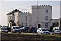
10
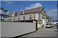
ACF Drill Hall, off Crantock Street
Built in 1900 and in use by G Company, 5th Battalion, Duke of Cornwall's Light Infantry in 1914. Remains in use by ACF today.
Image: © John M
Taken: 11 Sep 2014
0.17 miles