IMAGES TAKEN NEAR TO
Perrancoombe, PERRANPORTH, TR6 0JQ
Introduction
This page details the photographs taken nearby to TR6 0JQ by members of the Geograph project.
The Geograph project started in 2005 with the aim of publishing, organising and preserving representative images for every square kilometre of Great Britain, Ireland and the Isle of Man.

There are currently over 7.5m images from over14,400 individuals and you can help contribute to the project by visiting https://www.geograph.org.uk
Image Map
Images are licensed for reuse under creativecommons.org/licenses/by-sa/2.0
Notes
- Clicking on the map will re-center to the selected point.
- The higher the marker number, the further away the image location is from the centre of the postcode.
Image Listing (3 Images Found)
Images are licensed for reuse under creativecommons.org/licenses/by-sa/2.0
Image
Details
Distance
1
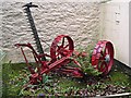
Old Mechanical Reaper
This piece of old farm machinery has been cleaned up and put on display by a local resident. This did not take power from the tractor like modern devices, the cutter was driven by the rotation of the wheels. On the hubcap of the wheel are the letters MH which I would guess might stand for Massey-Harris, a company formed in 1891 by the merger of two companies. The name died after 1953 on the merger with another company to form Massey-Ferguson.
Image: © Tony Atkin
Taken: 8 Oct 2005
0.15 miles
2
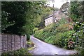
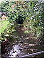
Minor road along the valley bottom at Carnbargus
Image: © Tony Atkin
Taken: 8 Oct 2005
0.19 miles