IMAGES TAKEN NEAR TO
Ridgeway, PERRANPORTH, TR6 0HW
Introduction
This page details the photographs taken nearby to Ridgeway, TR6 0HW by members of the Geograph project.
The Geograph project started in 2005 with the aim of publishing, organising and preserving representative images for every square kilometre of Great Britain, Ireland and the Isle of Man.

There are currently over 7.5m images from over14,400 individuals and you can help contribute to the project by visiting https://www.geograph.org.uk
Image Map
Images are licensed for reuse under creativecommons.org/licenses/by-sa/2.0
Notes
- Clicking on the map will re-center to the selected point.
- The higher the marker number, the further away the image location is from the centre of the postcode.
Image Listing (56 Images Found)
Images are licensed for reuse under creativecommons.org/licenses/by-sa/2.0
Image
Details
Distance
1
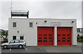
Perranporth Fire Station
Perranporth Fire Station, Station Road, Perranporth, Cornwall. One of a group of Cornish fire stations either replaced or refurbished under the government's Private Finance Initiative (PFI) scheme. This station is on the same site as the earlier fire station, and the corner girders of the original station have been 'wrapped up' in the new building.
Image: © Kevin Hale
Taken: 21 May 2006
0.11 miles
3
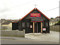
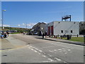
Perranporth, Christ the King
Christ the King Catholic Church, Wheal Leisure, Perranporth.
Image: © David Dixon
Taken: 28 Jul 2010
0.16 miles
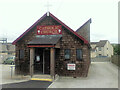
4
Perranporth Fire Station
Station Road, Perranporth
Image: © David Dixon
Taken: 28 Jul 2010
0.16 miles
5
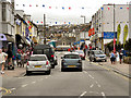
St Piran's Road, Perranporth
The main road (B3285) through Perranporth.
Image: © David Dixon
Taken: 28 Jul 2010
0.16 miles
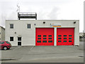
6
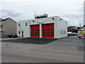
Perranporth fire station
A rather functional and modern station on the northern side of the town.
Image: © Richard Law
Taken: 21 Sep 2012
0.16 miles
8
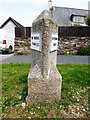
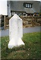
Old Milestone by the B3284, Liskey Hill in Perranporth
Stone post (replacement plates) by the B3284, in parish of PERRANZABULOE (CARRICK District), Perranporth, just before main road junction, on the verge, on North side of road. Erected by the Local Highways Board in the 19th century.
Inscription reads:-
: TO TRURO / 9 MILES : : TO PERRAN / PORTH :
Cornwall & Scilly HER.
HER Number: 178089 https://www.heritagegateway.org.uk/Gateway/Results_Single.aspx?uid=MCO53866&resourceID=1020
Milestone Society National ID: CW_TOPP09.
Image: © Rosy Hanns
Taken: 16 May 2019
0.17 miles
9
Old Milestone by the B3284, Liskey Hill in Perranporth
Stone post (plates lost) by the B3284, in parish of PERRANZABULOE (CARRICK District), Perranporth, just before main road junction, on the verge, on North side of road. Erected by the Local Highways Board in the 19th century.
Inscription once read:-
: (TRURO / 9) : : {plate missing} :
Milestone Society National ID: CW_TOPP09.
Image: © Ian Thompson
Taken: 1 Jul 1996
0.18 miles
10
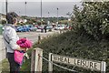
Site of the 'real' Wheal Leisure
Winston Graham's Poldark saga details many real life locations around Perranporth, where he wrote these novels. Wheal Leisure, the copper mine referred to in these works, now has no surface remains, but its flooded levels still lie beneath Perranporth's main street. The mine's name is commemorated by a small road to the north east of the town.
Image: © Richard Bird
Taken: 19 Sep 2014
0.18 miles