IMAGES TAKEN NEAR TO
Boscawen Road, PERRANPORTH, TR6 0EP
Introduction
This page details the photographs taken nearby to Boscawen Road, TR6 0EP by members of the Geograph project.
The Geograph project started in 2005 with the aim of publishing, organising and preserving representative images for every square kilometre of Great Britain, Ireland and the Isle of Man.

There are currently over 7.5m images from over14,400 individuals and you can help contribute to the project by visiting https://www.geograph.org.uk
Image Map
Images are licensed for reuse under creativecommons.org/licenses/by-sa/2.0
Notes
- Clicking on the map will re-center to the selected point.
- The higher the marker number, the further away the image location is from the centre of the postcode.
Image Listing (66 Images Found)
Images are licensed for reuse under creativecommons.org/licenses/by-sa/2.0
Image
Details
Distance
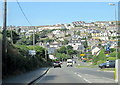
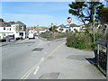
1
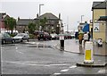
Perranporth town centre in the rain.
Just to show that it is not sunny all the time in Cornwall's holiday resorts!
Image: © Tony Atkin
Taken: 8 Oct 2005
0.03 miles
3
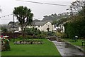
Gardens in Perranporth
Its raining but at least the gardens are green.
Image: © Tony Atkin
Taken: 8 Oct 2005
0.05 miles
5
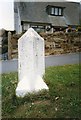
Old Milestone by the B3284, Liskey Hill in Perranporth
Stone post (plates lost) by the B3284, in parish of PERRANZABULOE (CARRICK District), Perranporth, just before main road junction, on the verge, on North side of road. Erected by the Local Highways Board in the 19th century.
Inscription once read:-
: (TRURO / 9) : : {plate missing} :
Milestone Society National ID: CW_TOPP09.
Image: © Ian Thompson
Taken: 1 Jul 1996
0.05 miles
6
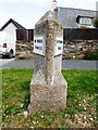
Old Milestone by the B3284, Liskey Hill in Perranporth
Stone post (replacement plates) by the B3284, in parish of PERRANZABULOE (CARRICK District), Perranporth, just before main road junction, on the verge, on North side of road. Erected by the Local Highways Board in the 19th century.
Inscription reads:-
: TO TRURO / 9 MILES : : TO PERRAN / PORTH :
Cornwall & Scilly HER.
HER Number: 178089 https://www.heritagegateway.org.uk/Gateway/Results_Single.aspx?uid=MCO53866&resourceID=1020
Milestone Society National ID: CW_TOPP09.
Image: © Rosy Hanns
Taken: 16 May 2019
0.05 miles
7
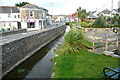
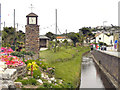
St George's Hill
Part of central Perranporth, where the western-most stream enters the village and has been channelled through to its outlet on the south side of Perran Bay. This is an attractive area of the village, just away from the main tourist "bit".
Image: © Graham Horn
Taken: 21 Oct 2011
0.05 miles
8
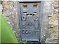
Ordnance Survey Flush Bracket S6870
This bracket can be found on the wall of St Michael's Church in Perranporth. The benchmark height is calculated as being 8.426 metres above sea level.
For more detail see : http://www.bench-marks.org.uk/bm11679
Image: © Peter Wood
Taken: 3 May 2017
0.06 miles
9
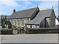
The Church of St Michael at Perranporth
Viewed from the south-east.
Image: © Peter Wood
Taken: 3 May 2017
0.06 miles