IMAGES TAKEN NEAR TO
Beach Lane, PERRANPORTH, TR6 0BQ
Introduction
This page details the photographs taken nearby to Beach Lane, TR6 0BQ by members of the Geograph project.
The Geograph project started in 2005 with the aim of publishing, organising and preserving representative images for every square kilometre of Great Britain, Ireland and the Isle of Man.

There are currently over 7.5m images from over14,400 individuals and you can help contribute to the project by visiting https://www.geograph.org.uk
Image Map
Images are licensed for reuse under creativecommons.org/licenses/by-sa/2.0
Notes
- Clicking on the map will re-center to the selected point.
- The higher the marker number, the further away the image location is from the centre of the postcode.
Image Listing (118 Images Found)
Images are licensed for reuse under creativecommons.org/licenses/by-sa/2.0
Image
Details
Distance
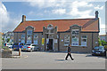
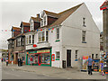
1
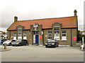
Perranporth Men's Institute
Behind the car park on Beach Road.
Image: © David Dixon
Taken: 28 Jul 2010
0.01 miles
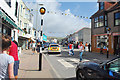
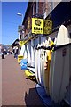
3
Some bargains to be had
Charity sale at the Mens Institute in Perranporth.
Image: © Robert Ashby
Taken: 17 Aug 2014
0.02 miles
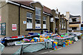
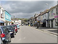
4
St Piran's Road
The B3285, through Perranporth.
Image: © David Dixon
Taken: 28 Jul 2010
0.03 miles
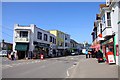
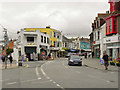
9
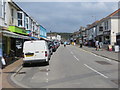
St Pirans Street (B3285) in Perranporth
Looking north-eastward.
Image: © Peter Wood
Taken: 3 May 2017
0.04 miles
10
Perranporth Post Office
St Piran's Road, Perranporth
Image: © David Dixon
Taken: 28 Jul 2010
0.04 miles