IMAGES TAKEN NEAR TO
Penwartha, PERRANPORTH, TR6 0AZ
Introduction
This page details the photographs taken nearby to TR6 0AZ by members of the Geograph project.
The Geograph project started in 2005 with the aim of publishing, organising and preserving representative images for every square kilometre of Great Britain, Ireland and the Isle of Man.

There are currently over 7.5m images from over14,400 individuals and you can help contribute to the project by visiting https://www.geograph.org.uk
Image Map
Images are licensed for reuse under creativecommons.org/licenses/by-sa/2.0
Notes
- Clicking on the map will re-center to the selected point.
- The higher the marker number, the further away the image location is from the centre of the postcode.
Image Listing (4 Images Found)
Images are licensed for reuse under creativecommons.org/licenses/by-sa/2.0
Image
Details
Distance
1
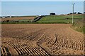
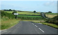
Farmland, Perranzabuloe
Arable land above Penwartha with the B3284 Ellestan Farm to the left.
Image: © Andrew Smith
Taken: 3 Apr 2022
0.16 miles
3
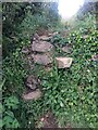
Stone Stile SW7551a
At field boundary about halfway along the footpath.
Sheep stile with two protruding steps on each side. Worn with use and rather dilapidated.
Public footpath 314/19/1 silver from Penwartha to the B3284 beside the electricity sub-station.
Image: © Linda Miners
Taken: 9 May 2021
0.21 miles
4
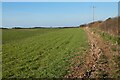
Farmland, Perranzabuloe
A footpath follows the edge of this field on its way to Penwartha.
Image: © Andrew Smith
Taken: 3 Apr 2022
0.25 miles