IMAGES TAKEN NEAR TO
Albany Close, ST. AGNES, TR5 0XE
Introduction
This page details the photographs taken nearby to Albany Close, TR5 0XE by members of the Geograph project.
The Geograph project started in 2005 with the aim of publishing, organising and preserving representative images for every square kilometre of Great Britain, Ireland and the Isle of Man.

There are currently over 7.5m images from over14,400 individuals and you can help contribute to the project by visiting https://www.geograph.org.uk
Image Map
Images are licensed for reuse under creativecommons.org/licenses/by-sa/2.0
Notes
- Clicking on the map will re-center to the selected point.
- The higher the marker number, the further away the image location is from the centre of the postcode.
Image Listing (2 Images Found)
Images are licensed for reuse under creativecommons.org/licenses/by-sa/2.0
Image
Details
Distance
1

Cornwall in Miniature, 1977
A fanciful castle in this tourist attraction that also featured more realistic models of Cornish tin mines and other Cornish features. It closed some time ago. St Agnes Beacon is in the distance.
Image: © Robin Webster
Taken: Unknown
0.22 miles
2
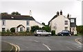
Goonbell
Goonbell is a ribbon development of houses stretching out to the south of St Agnes. This photograph shows the houses near the road junction at the centre of Goonbell.
Image: © Tony Atkin
Taken: 22 Oct 2005
0.24 miles