IMAGES TAKEN NEAR TO
West Polberro, ST. AGNES, TR5 0SS
Introduction
This page details the photographs taken nearby to TR5 0SS by members of the Geograph project.
The Geograph project started in 2005 with the aim of publishing, organising and preserving representative images for every square kilometre of Great Britain, Ireland and the Isle of Man.

There are currently over 7.5m images from over14,400 individuals and you can help contribute to the project by visiting https://www.geograph.org.uk
Image Map
Images are licensed for reuse under creativecommons.org/licenses/by-sa/2.0
Notes
- Clicking on the map will re-center to the selected point.
- The higher the marker number, the further away the image location is from the centre of the postcode.
Image Listing (19 Images Found)
Images are licensed for reuse under creativecommons.org/licenses/by-sa/2.0
Image
Details
Distance
1
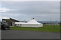
St Agnes Sports Club
Both football and rugby are played here but with a marquee on the pitch it looks like there is going to be a 'bit of a do' today instead.
Image: © Tony Atkin
Taken: 16 Jun 2007
0.06 miles
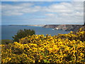
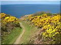
2
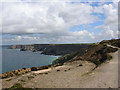
Cliffs from above Polberro Cove
Cliffs of Trevellas Porth (right) to Cligga Head (left) and in the far left the beach at Perranporth.
Seen from above Polberro Cove.
Image: © Joe Pritchard
Taken: 8 May 2005
0.06 miles
3
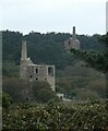
Former engine houses north of St Agnes
The nearer former engine house looks to have been converted to a modern dwelling of some style. I think that I have identified this correctly as Wheal Friendly Engine House. The more distant one is, I believe, the still ruinous Turnavore Engine House.
See shared description for more information and links.
Image: © Rob Farrow
Taken: 24 Sep 2023
0.06 miles
4
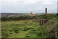
Old Mining Country
The land to the north west of St Agnes is riddled with old mines and mining waste. A few fields, probably for horse grazing, and gardens have been reclaimed from the gorse scrub covering the area. The scattered houses are probably now extremely expensive to buy.
Image: © Tony Atkin
Taken: 16 Jun 2007
0.09 miles
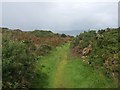
6
Gorse on the cliff top at Polberrow
Looking along the coast towards Penhale.
Image: © Rod Allday
Taken: 5 May 2013
0.12 miles
7
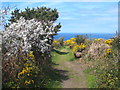
Footpath leading to the coast path at Polberrow
A beautiful display of blackthorn & gorse blossom lining the path.
Image: © Rod Allday
Taken: 5 May 2013
0.14 miles
8
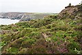
Clifftop near St Agnes
Mining and quarrying has scarred the landscape here but after a time heather and gorse take up residence on the waste ground.
Image: © Tony Atkin
Taken: 16 Jun 2007
0.14 miles
9
Cliff top path at Polberrow
A beautiful display of gorse blossom this year.
Image: © Rod Allday
Taken: 5 May 2013
0.15 miles
10
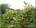
Japanese Knotweed (Fallopia japonica)
This invasive weed was introduced to this country in Victorian times by plant collectors, who found it an attractive plant. However, it migrated from private gardens to the wild and it is nowadays a serious problem, particularly in Cornwall. It is very difficult to eliminate because of its ability to regenerate from small relics of tissue. http://projects.exeter.ac.uk/knotweed/. It is quite widespread on this particular area of old mining waste.
Image: © Rod Allday
Taken: 6 Sep 2009
0.16 miles