IMAGES TAKEN NEAR TO
Tregease Road, ST. AGNES, TR5 0SL
Introduction
This page details the photographs taken nearby to Tregease Road, TR5 0SL by members of the Geograph project.
The Geograph project started in 2005 with the aim of publishing, organising and preserving representative images for every square kilometre of Great Britain, Ireland and the Isle of Man.

There are currently over 7.5m images from over14,400 individuals and you can help contribute to the project by visiting https://www.geograph.org.uk
Image Map (Loading...)


Getting Data...Please wait
Leaflet Map data © OpenStreetMap
Images are licensed for reuse under creativecommons.org/licenses/by-sa/2.0
Notes
- Clicking on the map will re-center to the selected point.
- The higher the marker number, the further away the image location is from the centre of the postcode.
Image Listing (45 Images Found)
Images are licensed for reuse under creativecommons.org/licenses/by-sa/2.0
Image
Details
Distance
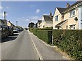
1
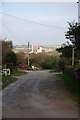
The Start of Whealfriendly Lane
I assume the mine in the background is Whealfriendly.
Image: © Glyn Baker
Taken: 3 Oct 2015
0.09 miles
7
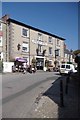
The St Agnes Hotel
As the bus stopped right outside it would be rude not to pop in for a quick one!
Image: © Glyn Baker
Taken: 3 Oct 2015
0.14 miles
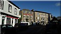
10
Town Hill, St Agnes
The top of Town Hill, where it meets Vicarage Road.
Image: © David Dixon
Taken: 3 Jun 2023
0.15 miles