IMAGES TAKEN NEAR TO
Trevaunance Road, ST. AGNES, TR5 0SG
Introduction
This page details the photographs taken nearby to Trevaunance Road, TR5 0SG by members of the Geograph project.
The Geograph project started in 2005 with the aim of publishing, organising and preserving representative images for every square kilometre of Great Britain, Ireland and the Isle of Man.

There are currently over 7.5m images from over14,400 individuals and you can help contribute to the project by visiting https://www.geograph.org.uk
Image Map
Images are licensed for reuse under creativecommons.org/licenses/by-sa/2.0
Notes
- Clicking on the map will re-center to the selected point.
- The higher the marker number, the further away the image location is from the centre of the postcode.
Image Listing (18 Images Found)
Images are licensed for reuse under creativecommons.org/licenses/by-sa/2.0
Image
Details
Distance
1
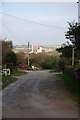
The Start of Whealfriendly Lane
I assume the mine in the background is Whealfriendly.
Image: © Glyn Baker
Taken: 3 Oct 2015
0.13 miles

3
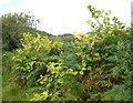
Japanese Knotweed (Fallopia japonica)
This invasive weed was introduced to this country in Victorian times by plant collectors, who found it an attractive plant. However, it migrated from private gardens to the wild and it is nowadays a serious problem, particularly in Cornwall. It is very difficult to eliminate because of its ability to regenerate from small relics of tissue. http://projects.exeter.ac.uk/knotweed/. It is quite widespread on this particular area of old mining waste.
Image: © Rod Allday
Taken: 6 Sep 2009
0.15 miles


6
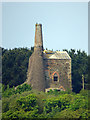
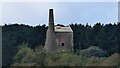
Polberro Mine, Turnavore Shaft - St Agnes
This engine house had been converted to a miner's dry and as a consequence looks a little unusual with a more modern roof, walled in bob opening and gothic windows. It was built in 1885 for a 60" pumping engine built in 1863 by Harvey & Co. In 1902 it was moved to the nearby Wheal Friendly. Polberro was a tin mine and finally closed after an attempt at reworking in 1941. The engine house had been modified for this reworking in 1937 and is now on private land. The photographer's position is approximate.
Image: © Chris Allen
Taken: 21 May 2018
0.16 miles
7
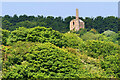
Turnavore Engine House
A view from the coastal path near Trevaunance Cove. Disused, late nineteenth-century pumping beam engine house, it is Grade II-listed (List Entry Number:1141491 https://historicengland.org.uk/listing/the-list/list-entry/1141491 Historic England).
For further information, see Image
Image: © David Dixon
Taken: 3 Jun 2023
0.17 miles
8
Turnavore engine house
Pumping engine house. https://www.heritagegateway.org.uk/Gateway/Results_Single.aspx?uid=MCO52642&resourceID=1020
Image: © Sandy Gerrard
Taken: 12 Sep 2019
0.17 miles
9
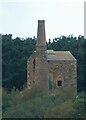
Turnavore Engine House
Turnavore Engine House is a former pumping beam engine house dating from the mid to late C19th.
See shared description below:
Image: © Rob Farrow
Taken: 24 Sep 2023
0.17 miles
10

St Agnes Sports Club
Both football and rugby are played here but with a marquee on the pitch it looks like there is going to be a 'bit of a do' today instead.
Image: © Tony Atkin
Taken: 16 Jun 2007
0.17 miles