IMAGES TAKEN NEAR TO
The Terrace, ST. AGNES, TR5 0QG
Introduction
This page details the photographs taken nearby to The Terrace, TR5 0QG by members of the Geograph project.
The Geograph project started in 2005 with the aim of publishing, organising and preserving representative images for every square kilometre of Great Britain, Ireland and the Isle of Man.

There are currently over 7.5m images from over14,400 individuals and you can help contribute to the project by visiting https://www.geograph.org.uk
Image Map (Loading...)


Getting Data...Please wait
Leaflet Map data © OpenStreetMap
Images are licensed for reuse under creativecommons.org/licenses/by-sa/2.0
Notes
- Clicking on the map will re-center to the selected point.
- The higher the marker number, the further away the image location is from the centre of the postcode.
Image Listing (19 Images Found)
Images are licensed for reuse under creativecommons.org/licenses/by-sa/2.0
Image
Details
Distance
1
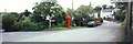
Mithian centre crossroads
The road on the left leads east down to Rose-In-Vale, and the road on the right leads to Mithian Downs to the south. This picture panoramically aligns with my photo of Miner's Arms at left edge. In-camera panorama.
Image: © Elaine Hamby
Taken: Unknown
0.02 miles
2
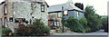
Miner's Arms pub, Mithian
The road on the right leads down to Rose-in-Vale to the east. The right edge of this photo panoramically aligns with my photo of the Mithian centre crossroads, and the left edge aligns to the photo of Mithian Road west of Miner's Arms.
Image: © Elaine Hamby
Taken: Unknown
0.02 miles
3
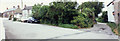
Mithian Road west of Miner's Arms
This road leads to Barkla Shop and the B 3285 to the west. The right edge of this photo aligns panoramically to my picture of the Miner's Arms Pub, in the centre of Mithian village. Three images fit together. In-camera panorama.
Image: © Elaine Hamby
Taken: Unknown
0.02 miles
4
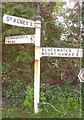
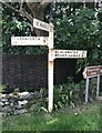
Old Direction Sign - Signpost in Mithian village, St Agnes Parish
Cone finial - Missing arm has wooden replacement; Oatey and Martyn casting by the UC road, in parish of St Agnes (Carrick District), Mithian village, opposite the Miners Arms, on verge at junction near phone box.
Surveyed
Milestone Society National ID: CW_SW7450B
Image: © Milestone Society
Taken: Unknown
0.04 miles
5
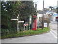
Direction Sign - Signpost in Mithian village
Located on the southeast side of the junction at the centre of Mithian village opposite the Miners Arm. St Agnes parish. 3 arms and cone finial. The St Agnes arm is a replacement arm for an even older wooden replacement to be seen in https://www.geograph.org.uk/photo/6043160.
Milestone Society National ID: CW_SW7450B
Image: © P Barnett
Taken: 18 Jun 2024
0.04 miles
8
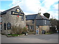
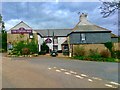
The Miner's Arms in Mithian
Dating from the C17th and Grade II listed http://www.imagesofengland.org.uk/Details/Default.aspx?id=63802&mode=adv.
Image: © Rod Allday
Taken: 21 Jan 2011
0.04 miles
9
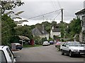
Mithian Village
Looking down the road from near to the old post office. The chalked signboard on the left advertises the local pub, the Miner's Arms which is just out of sight on the left. I suppose that visitors driving through the village in this direction might just miss seeing the pub without it.
Image: © Tony Atkin
Taken: 8 Oct 2005
0.05 miles
10
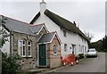
The Old Post Office, Mithian
The white thatched building has a name plaque identifying it as "The Old Post Office". I do not know what the building in front of it was originally but it looks a lot like it may have originally been a school house, although a very small one. Please post a comment in this square's discussion forum if you have more information.
Image: © Tony Atkin
Taken: 8 Oct 2005
0.07 miles