
IMAGES TAKEN NEAR TO
Goshen, ST. AGNES, TR5 0QB
Introduction
This page details the photographs taken nearby to TR5 0QB by members of the Geograph project.
The Geograph project started in 2005 with the aim of publishing, organising and preserving representative images for every square kilometre of Great Britain, Ireland and the Isle of Man.

There are currently over 7.5m images from over14,400 individuals and you can help contribute to the project by visiting https://www.geograph.org.uk
Image Map
Images are licensed for reuse under creativecommons.org/licenses/by-sa/2.0
Notes
- Clicking on the map will re-center to the selected point.
- The higher the marker number, the further away the image location is from the centre of the postcode.
Image Listing (17 Images Found)
Images are licensed for reuse under creativecommons.org/licenses/by-sa/2.0
Image
Details
Distance
1
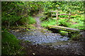
Mithian Ford
This ford is found on the bridleway leading up from Mithian.
Image: © John Walton
Taken: 22 Sep 2015
0.10 miles
4
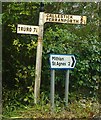
Old Direction Sign - Signpost east of Mithian, St Agnes
Pyramid finial - 2 arms; by the UC road, in parish of St Agnes (Carrick District), East of Mithian village, beside village entry sign.
To be surveyed
Milestone Society National ID: CW_SW7450C
Image: © Milestone Society
Taken: Unknown
0.14 miles
5
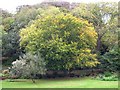
Valley bottom east of Mithian
Autumn in Cornwall is not noted for its colourful fall display. With its mild and windy climate, leaves on trees tend to go brown and then blow away in the first gale which comes along. This touch of Autumn colour in the sheltered valley bottom to the east of Mithian village is about as good as it gets.
Image: © Tony Atkin
Taken: 8 Oct 2005
0.16 miles
7
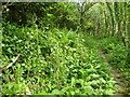
Hedge alongside the footpath
The hedge is a Cornish hedge, which is a stone-faced structure covered with vegetation.
Image: © Rod Allday
Taken: 18 May 2023
0.17 miles
8
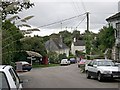
Mithian Village
Looking down the road from near to the old post office. The chalked signboard on the left advertises the local pub, the Miner's Arms which is just out of sight on the left. I suppose that visitors driving through the village in this direction might just miss seeing the pub without it.
Image: © Tony Atkin
Taken: 8 Oct 2005
0.19 miles
9
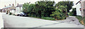
Mithian Road west of Miner's Arms
This road leads to Barkla Shop and the B 3285 to the west. The right edge of this photo aligns panoramically to my picture of the Miner's Arms Pub, in the centre of Mithian village. Three images fit together. In-camera panorama.
Image: © Elaine Hamby
Taken: Unknown
0.20 miles
10
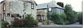
Miner's Arms pub, Mithian
The road on the right leads down to Rose-in-Vale to the east. The right edge of this photo panoramically aligns with my photo of the Mithian centre crossroads, and the left edge aligns to the photo of Mithian Road west of Miner's Arms.
Image: © Elaine Hamby
Taken: Unknown
0.20 miles