IMAGES TAKEN NEAR TO
Wheal Butson, ST. AGNES, TR5 0PX
Introduction
This page details the photographs taken nearby to TR5 0PX by members of the Geograph project.
The Geograph project started in 2005 with the aim of publishing, organising and preserving representative images for every square kilometre of Great Britain, Ireland and the Isle of Man.

There are currently over 7.5m images from over14,400 individuals and you can help contribute to the project by visiting https://www.geograph.org.uk
Image Map
Images are licensed for reuse under creativecommons.org/licenses/by-sa/2.0
Notes
- Clicking on the map will re-center to the selected point.
- The higher the marker number, the further away the image location is from the centre of the postcode.
Image Listing (13 Images Found)
Images are licensed for reuse under creativecommons.org/licenses/by-sa/2.0
Image
Details
Distance
1
Bridge over a disused railway
Bridge over a disused railway to the east of Goonbell viaduct. This bridge is almost on the juncture of four grid squares. I checked its location with GPS reading.
Image: © Philip Halling
Taken: 31 Dec 2014
0.04 miles
2
Remains of a railway
Remains of a railway passing through a cutting as it approaches Goonbell viaduct.
Image: © Philip Halling
Taken: 31 Dec 2014
0.05 miles
3
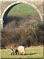
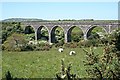
Sheep and lambs at Mithian Downs
With a backdrop of the disused railway viaduct Image
Image: © Rod Allday
Taken: 21 Jan 2011
0.09 miles
4
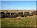
Railway viaduct on Mithian Downs
A remnant from the Perranporth to Chacewater Railway, closed as a result of the Beeching cuts in the 1960s.
Image: © Rod Allday
Taken: 21 Jan 2011
0.11 miles
5
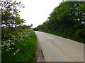
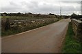
Minor road approaching a bend by Fair View Farm
Image: © Rod Allday
Taken: 18 May 2023
0.13 miles
6
Disused Railway Viaduct
This used to carry a single-track line over the Trevellas Valley.
Image: © Tony Atkin
Taken: 2 Jun 2006
0.14 miles
7
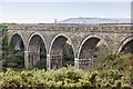
Wheal Liberty viaduct
Much of the track bed of the Chacewater to Newquay branch line has been destroyed and many cuttings filled in. But one fine feature remains between Goonbell and Mithian. Built by the contractor Arthur Carkeek of Redruth in 1902, and named after a nearby mine, it remains in good condition, hidden away from main roads. The usual shoulder high gorse and brambles makes exploration of this structure well nigh impossible!
Image: © Richard Bird
Taken: 15 Sep 2014
0.14 miles
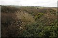
8
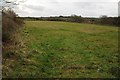
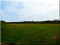
Field on Mithian Downs
One of a number of small fields at Mithian Downs.
Image: © Philip Halling
Taken: 31 Dec 2014
0.15 miles
10
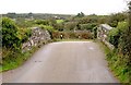
Bridge over the dismantled railway line at Mithian
This bridge used to carry the road from Mithian Down to Mithian over the Perranporth Railway branch line. The line has been closed for many years. Over the bridge is the land around the village of Mithian. The village itself is behind the trees on the right hand side of the picture.
Image: © Tony Atkin
Taken: 8 Oct 2005
0.24 miles