IMAGES TAKEN NEAR TO
Scoll Bridge, ST. AGNES, TR5 0PE
Introduction
This page details the photographs taken nearby to Scoll Bridge, TR5 0PE by members of the Geograph project.
The Geograph project started in 2005 with the aim of publishing, organising and preserving representative images for every square kilometre of Great Britain, Ireland and the Isle of Man.

There are currently over 7.5m images from over14,400 individuals and you can help contribute to the project by visiting https://www.geograph.org.uk
Image Map
Images are licensed for reuse under creativecommons.org/licenses/by-sa/2.0
Notes
- Clicking on the map will re-center to the selected point.
- The higher the marker number, the further away the image location is from the centre of the postcode.
Image Listing (8 Images Found)
Images are licensed for reuse under creativecommons.org/licenses/by-sa/2.0
Image
Details
Distance
1
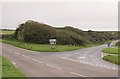
Road junction east of Mingoose
The line of shrubs following the side road stop by the main road at a stone wall which is all that is left of the railway bridge on the old Perranporth line.
Image: © Tony Atkin
Taken: 22 Oct 2005
0.13 miles
2
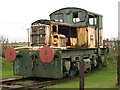
Old Diesel Locomotive
This old Diesel shunter is parked on a few yards of track laid out by the main road.
Image: © Tony Atkin
Taken: 22 Oct 2005
0.13 miles
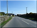
4
Minor road between Mount Hawke and St Agnes
Image: © Rod Allday
Taken: 5 May 2013
0.15 miles
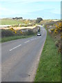
5
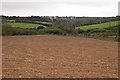
Ploughed Field east of Mingoose
Most of the land around here is pasture, but not all of it.
Image: © Tony Atkin
Taken: 22 Oct 2005
0.16 miles
6
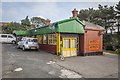
St Agnes Railway station
The railway between Chacewater and Perranporth was opened for passenger traffic on the 6th of July 1903 and between Perranporth and Newquay on the 2nd July 1905. The line lasted until 1963 and was one of the first casualties of the Beeching Report. This station, now surrounded by a small industrial estate, waved the last train goodbye on the 4th Of February 1963.
Image: © Richard Bird
Taken: 15 Sep 2014
0.17 miles
7
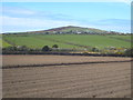
Ploughed field near Mingoose
St Agnes Beacon is in the distance.
Image: © Rod Allday
Taken: 5 May 2013
0.19 miles
8

A Pointless Bridge
The road rises steeply to take this bridge but the railway line which it crosses was removed years ago.
Image: © Tony Atkin
Taken: 22 Oct 2005
0.22 miles