IMAGES TAKEN NEAR TO
Goonvrea, ST. AGNES, TR5 0NL
Introduction
This page details the photographs taken nearby to Goonvrea, TR5 0NL by members of the Geograph project.
The Geograph project started in 2005 with the aim of publishing, organising and preserving representative images for every square kilometre of Great Britain, Ireland and the Isle of Man.

There are currently over 7.5m images from over14,400 individuals and you can help contribute to the project by visiting https://www.geograph.org.uk
Image Map (Loading...)


Getting Data...Please wait
Leaflet Map data © OpenStreetMap
Images are licensed for reuse under creativecommons.org/licenses/by-sa/2.0
Notes
- Clicking on the map will re-center to the selected point.
- The higher the marker number, the further away the image location is from the centre of the postcode.
Image Listing (8 Images Found)
Images are licensed for reuse under creativecommons.org/licenses/by-sa/2.0
Image
Details
Distance
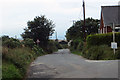
1
Road at the entrance to Goonvrea Farm
Looking southward.
Image: © Peter Wood
Taken: 3 May 2017
0.07 miles
2
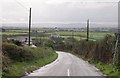
Farmland in a shallow valley
This was taken from the crossroads at Bolster and looks south across a shallow valley to Goonvrea Farm.
Image: © Tony Atkin
Taken: 22 Oct 2005
0.08 miles
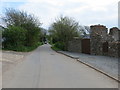
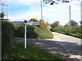
3
Cornish hedges south of Bolster
Looking from the crossroads at Bolster, with banks and hedges on each side of the road
Image: © David Smith
Taken: 11 Mar 2016
0.12 miles
4
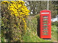
Roadside telephone box at Higher Goonvrea
The newly-painted telephone box and the gorse blossom making a beautiful splash of colour.
Image: © Rod Allday
Taken: 5 May 2013
0.18 miles
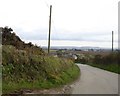
5
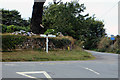
Road junction
Crossroads near St Agnes
Image: © Robert Ashby
Taken: 17 Aug 2014
0.18 miles
7
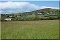
Pasture, St Agnes
St Agnes Beacon rising to the north of Goonvrea.
Image: © Andrew Smith
Taken: 8 May 2022
0.19 miles