IMAGES TAKEN NEAR TO
Park An Dre, ST. AGNES, TR5 0AN
Introduction
This page details the photographs taken nearby to Park An Dre, TR5 0AN by members of the Geograph project.
The Geograph project started in 2005 with the aim of publishing, organising and preserving representative images for every square kilometre of Great Britain, Ireland and the Isle of Man.

There are currently over 7.5m images from over14,400 individuals and you can help contribute to the project by visiting https://www.geograph.org.uk
Image Map (Loading...)


Getting Data...Please wait
Leaflet Map data © OpenStreetMap
Images are licensed for reuse under creativecommons.org/licenses/by-sa/2.0
Notes
- Clicking on the map will re-center to the selected point.
- The higher the marker number, the further away the image location is from the centre of the postcode.
Image Listing (9 Images Found)
Images are licensed for reuse under creativecommons.org/licenses/by-sa/2.0
Image
Details
Distance
1

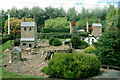
Cornwall in Miniature, 1977
A fanciful castle in this tourist attraction that also featured more realistic models of Cornish tin mines and other Cornish features. It closed some time ago. St Agnes Beacon is in the distance.
Image: © Robin Webster
Taken: Unknown
0.03 miles
2
Wheal Duchy, 1977
A model tin mine, in the 'Cornwall in Miniature' tourist attraction, now closed and built over. What became of the large number of rather wonderful models?
Image: © Robin Webster
Taken: Unknown
0.09 miles
3
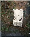
Old Milestone by the B3277, south of Goonown
Stone post (original plates lost) by the B3277, in parish of ST AGNES (CARRICK District), North of filling station, before St Agnes Leisure Centre, on South side of road. Erected by the Local Highways Board in the 19th century.
Inscription reads:-
: ST AGNES / 1 MILE : : REDRUTH / 6½ MILES / TRURO / 8 MILES :
(new plates now fitted)
Carved benchmark on lower front face.
Cornwall & Scilly HER listed.
HER Number: 178082 https://www.heritagegateway.org.uk/Gateway/Results_Single.aspx?uid=MCO53859&resourceID=1020
Milestone Society National ID: CW_TOAG08a.
Image: © Ian Thompson
Taken: Unknown
0.12 miles
4
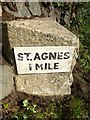
Old Milestone by the B3277, south of Goonown
Stone post (original plates lost) by the B3277, in parish of ST AGNES (CARRICK District), North of filling station, before St Agnes Leisure Centre, on West side of road. Erected by the Local Highways Board in the 19th century.
Inscription on new plates reads:-
: ST.AGNES / 1 MILE : : REDRUTH / 6½ MILES / TRURO / 8 MILES :
Carved benchmark and rivet on front top.
Cornwall & Scilly HER.
HER Number: 178082 https://www.heritagegateway.org.uk/Gateway/Results_Single.aspx?uid=MCO53859&resourceID=1020
Milestone Society National ID: CW_TOAG08a.
Image: © Rosy Hanns
Taken: 9 Jun 2019
0.12 miles
5

Houses, St Agnes
A recent development beside Endean Farm has expanded the southern edge of the village.
Image: © Andrew Smith
Taken: 8 May 2022
0.13 miles
6
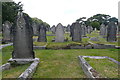
St Agnes burial ground
This is the burial ground of the former chapel, now the village museum. It is still an active burial ground though.
Image: © Graham Horn
Taken: 8 Jul 2011
0.21 miles
7
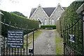
St Agnes museum
The small museum about the tin mining and St Agnes's industrial past is housed in this former chapel. Hence, you appear to be entering a burial ground. You are. Dog owners obviously need to be told twice to keep their animals on a close/short lead.
Image: © Graham Horn
Taken: 8 Jul 2011
0.21 miles
8
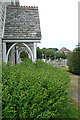
St Agnes museum
This is the east face of the museum, formerly a chapel, with its burial ground around it.
Image: © Graham Horn
Taken: 8 Jul 2011
0.21 miles