IMAGES TAKEN NEAR TO
Treamble, TRURO, TR4 9PR
Introduction
This page details the photographs taken nearby to Treamble, TR4 9PR by members of the Geograph project.
The Geograph project started in 2005 with the aim of publishing, organising and preserving representative images for every square kilometre of Great Britain, Ireland and the Isle of Man.

There are currently over 7.5m images from over14,400 individuals and you can help contribute to the project by visiting https://www.geograph.org.uk
Image Map
Images are licensed for reuse under creativecommons.org/licenses/by-sa/2.0
Notes
- Clicking on the map will re-center to the selected point.
- The higher the marker number, the further away the image location is from the centre of the postcode.
Image Listing (5 Images Found)
Images are licensed for reuse under creativecommons.org/licenses/by-sa/2.0
Image
Details
Distance
1
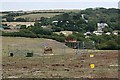
Caravans in the Valley
There used to be mines here, now it is a mixture of agriculture and tourism so common in Cornwall.
Image: © Tony Atkin
Taken: 4 Aug 2006
0.15 miles
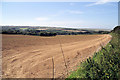
2
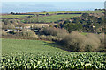
Farmland, Perranzabuloe
A crop of cauliflowers on the hillside to the east of Mount.
Image: © Andrew Smith
Taken: 12 Feb 2023
0.20 miles
4
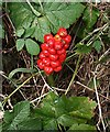
Wild Arum Fruit
A very distinctive fruit spike sticking out of the bottom of the hedgerow. This plant is very common in the hedgerows locally. It is also known as 'Cuckoo Pint' and 'Lords and Ladies'. It is poisonous.
Image: © Tony Atkin
Taken: 4 Aug 2006
0.23 miles
5
Fields near Rejerrah
A field sown with some sort of brassica.
Image: © Pierre Terre
Taken: 25 Jul 2008
0.24 miles