IMAGES TAKEN NEAR TO
Wheal Frances, TRURO, TR4 9NR
Introduction
This page details the photographs taken nearby to Wheal Frances, TR4 9NR by members of the Geograph project.
The Geograph project started in 2005 with the aim of publishing, organising and preserving representative images for every square kilometre of Great Britain, Ireland and the Isle of Man.

There are currently over 7.5m images from over14,400 individuals and you can help contribute to the project by visiting https://www.geograph.org.uk
Image Map
Images are licensed for reuse under creativecommons.org/licenses/by-sa/2.0
Notes
- Clicking on the map will re-center to the selected point.
- The higher the marker number, the further away the image location is from the centre of the postcode.
Image Listing (3 Images Found)
Images are licensed for reuse under creativecommons.org/licenses/by-sa/2.0
Image
Details
Distance
2
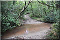
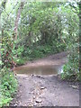
Ford at Wheal Frances
This ford is found along the track leading to Wheal Frances.
Image: © John Walton
Taken: 21 Sep 2015
0.24 miles
3
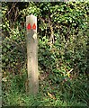
Path Direction Post
Red is for byway and yellow for footpath. If there were a bridleway here too it would have been pointed out in blue.
Image: © Tony Atkin
Taken: 15 Oct 2005
0.24 miles