IMAGES TAKEN NEAR TO
Penhallow, TRURO, TR4 9LY
Introduction
This page details the photographs taken nearby to TR4 9LY by members of the Geograph project.
The Geograph project started in 2005 with the aim of publishing, organising and preserving representative images for every square kilometre of Great Britain, Ireland and the Isle of Man.

There are currently over 7.5m images from over14,400 individuals and you can help contribute to the project by visiting https://www.geograph.org.uk
Image Map
Images are licensed for reuse under creativecommons.org/licenses/by-sa/2.0
Notes
- Clicking on the map will re-center to the selected point.
- The higher the marker number, the further away the image location is from the centre of the postcode.
Image Listing (6 Images Found)
Images are licensed for reuse under creativecommons.org/licenses/by-sa/2.0
Image
Details
Distance
1
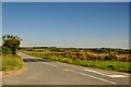
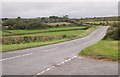
Carrick : Road Junction
This road heads from the B3284 towards the A3075.
Image: © Lewis Clarke
Taken: 3 Jul 2011
0.17 miles
2
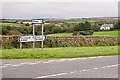
At the Crossroads
Notice the windfarm just visible on the horizon.
Image: © Tony Atkin
Taken: 8 Oct 2005
0.18 miles
3
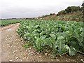
Cabbages
Brassicas are a major Autumn crop in Cornwall. The hedgebank on the right is topped with gorse.
Image: © Tony Atkin
Taken: 8 Oct 2005
0.21 miles
4
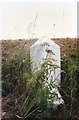
Old Milestone by the B3284, south of Higher Golla
Stone post (plates lost) by the B3284, in parish of PERRANZABULOE (CARRICK District), Higher Golla, by the road, on West side of road. Erected by the Local Highways Board in the 19th century.
Inscription once read:-
: (PERRANPORTH / 2) : : (TRURO / 7) :
Milestone Society National ID: CW_TOPP07.
Image: © Ian Thompson
Taken: 1 Jul 1996
0.23 miles
5
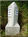
Old Milestone by the B3284, south of Higher Golla
Stone post (replacement plates) by the B3284, in parish of PERRANZABULOE (CARRICK District), Higher Golla, by the road, on West side of road. Erected by the Local Highways Board in the 19th century.
Inscription reads:-
: TO PERRAN / PORTH / 2 MILES : : TO TRURO / 7 MILES :
Cornwall & Scilly HER.
HER Number: 178085 https://www.heritagegateway.org.uk/Gateway/Results_Single.aspx?uid=MCO53862&resourceID=1020
Milestone Society National ID: CW_TOPP07.
Image: © Rosy Hanns
Taken: 17 May 2019
0.23 miles
6
The Road To Perranporth
This is the main road to Perranport from the south. It keeps to the top of a long north-south ridge between two river valleys. The road goes through mixed agricultural land. This picture looks along the road to the south. The minor road in the foreground leads to the village of Mithian.
Image: © Tony Atkin
Taken: 8 Oct 2005
0.23 miles