IMAGES TAKEN NEAR TO
Penhallow, TRURO, TR4 9LT
Introduction
This page details the photographs taken nearby to TR4 9LT by members of the Geograph project.
The Geograph project started in 2005 with the aim of publishing, organising and preserving representative images for every square kilometre of Great Britain, Ireland and the Isle of Man.

There are currently over 7.5m images from over14,400 individuals and you can help contribute to the project by visiting https://www.geograph.org.uk
Image Map
Images are licensed for reuse under creativecommons.org/licenses/by-sa/2.0
Notes
- Clicking on the map will re-center to the selected point.
- The higher the marker number, the further away the image location is from the centre of the postcode.
Image Listing (6 Images Found)
Images are licensed for reuse under creativecommons.org/licenses/by-sa/2.0
Image
Details
Distance
1
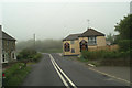
At the sign of Prince Charles
I wonder if a percentage goes to the Duchy?
Image: © David Long
Taken: 10 May 2006
0.02 miles
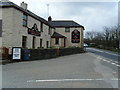
4
Turning to the Cornish Cyder Farm
On the A3075 Redruth - Newquay road
Image: © David Long
Taken: 10 May 2006
0.12 miles
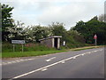
5
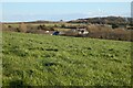
Pasture, Perranzabuloe
Looking towards Penhallow from the byway at Lambriggan.
Image: © Andrew Smith
Taken: 3 Apr 2022
0.12 miles
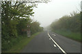
6
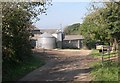
Farmyard at Lambriggan
In most respects a typical farmyard with a mixture of old buildings and modern "shiny metal" technologies.
Image: © Tony Atkin
Taken: 15 Oct 2005
0.23 miles