IMAGES TAKEN NEAR TO
Callestick, TRURO, TR4 9LJ
Introduction
This page details the photographs taken nearby to TR4 9LJ by members of the Geograph project.
The Geograph project started in 2005 with the aim of publishing, organising and preserving representative images for every square kilometre of Great Britain, Ireland and the Isle of Man.

There are currently over 7.5m images from over14,400 individuals and you can help contribute to the project by visiting https://www.geograph.org.uk
Image Map
Images are licensed for reuse under creativecommons.org/licenses/by-sa/2.0
Notes
- Clicking on the map will re-center to the selected point.
- The higher the marker number, the further away the image location is from the centre of the postcode.
Image Listing (4 Images Found)
Images are licensed for reuse under creativecommons.org/licenses/by-sa/2.0
Image
Details
Distance
1
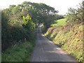
Minor Road through Farmland
looking west up the hill from a road junction to the southwest of Ventongimps.
Image: © Tony Atkin
Taken: 15 Oct 2005
0.07 miles
2
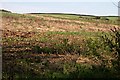
Set-aside
Set-aside land is left for a year without crops being grown on it. This practice used to be called fallowing.
Image: © Tony Atkin
Taken: 15 Oct 2005
0.09 miles
3
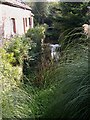
Ventongimps Mill and stream
This scene probably looks a lot prettier now than when the mill was working.
Image: © Tony Atkin
Taken: 15 Oct 2005
0.13 miles
4
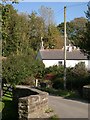
Ventongimps
This is a leafy valley bottom residential and tourist hamlet. It grew up around a water mill in the valley bottom and was known as Ventongimps Mill.
Image: © Tony Atkin
Taken: 15 Oct 2005
0.15 miles