IMAGES TAKEN NEAR TO
Goonhavern, TRURO, TR4 9JR
Introduction
This page details the photographs taken nearby to TR4 9JR by members of the Geograph project.
The Geograph project started in 2005 with the aim of publishing, organising and preserving representative images for every square kilometre of Great Britain, Ireland and the Isle of Man.

There are currently over 7.5m images from over14,400 individuals and you can help contribute to the project by visiting https://www.geograph.org.uk
Image Map
Images are licensed for reuse under creativecommons.org/licenses/by-sa/2.0
Notes
- Clicking on the map will re-center to the selected point.
- The higher the marker number, the further away the image location is from the centre of the postcode.
Image Listing (8 Images Found)
Images are licensed for reuse under creativecommons.org/licenses/by-sa/2.0
Image
Details
Distance
1
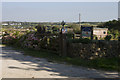
Reen Cross Farm caravan site
Entrance to the caravan site at Reen Cross Farm.
Image: © Elizabeth Scott
Taken: 7 Sep 2012
0.17 miles
3
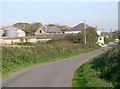
Farm at Reen Cross
This farm occupies rather exposed hilltop land between Goonhavern and Perranporth.
Image: © Tony Atkin
Taken: 15 Oct 2005
0.19 miles
4
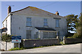
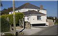
House at Reen Cross
House at Reen Cross, possibly the farmhouse.
Image: © Elizabeth Scott
Taken: 7 Sep 2012
0.19 miles
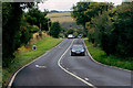
5
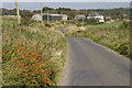
View to Reen Cross
View along the minor road to Reen Cross.
Image: © Elizabeth Scott
Taken: 7 Sep 2012
0.21 miles
6
Swallow cottage holiday let
Swallow cottage holiday let at Reen Cross Farm.
Image: © Elizabeth Scott
Taken: 7 Sep 2012
0.21 miles
7
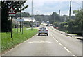
Cornwall Goonhavern Village Boundary Sign
Image: © Roy Hughes
Taken: 5 Sep 2013
0.24 miles
8
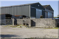
Farm buildings at Reen Cross
Barns at Reen Cross farm.
Image: © Elizabeth Scott
Taken: 7 Sep 2012
0.24 miles