IMAGES TAKEN NEAR TO
Zelah, TRURO, TR4 9JB
Introduction
This page details the photographs taken nearby to TR4 9JB by members of the Geograph project.
The Geograph project started in 2005 with the aim of publishing, organising and preserving representative images for every square kilometre of Great Britain, Ireland and the Isle of Man.

There are currently over 7.5m images from over14,400 individuals and you can help contribute to the project by visiting https://www.geograph.org.uk
Image Map
Images are licensed for reuse under creativecommons.org/licenses/by-sa/2.0
Notes
- Clicking on the map will re-center to the selected point.
- The higher the marker number, the further away the image location is from the centre of the postcode.
Image Listing (19 Images Found)
Images are licensed for reuse under creativecommons.org/licenses/by-sa/2.0
Image
Details
Distance
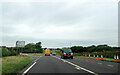
1

St Allen : A30
The A30 heading through the St Allen parish.
Image: © Lewis Clarke
Taken: 22 Oct 2019
0.01 miles
2
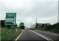
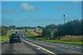
A30 on Zelah Hill approaching B3285 turning for Perranporth
Image: © Roy Hughes
Taken: 2 Jul 2021
0.02 miles
4
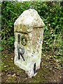
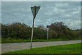
Old Milestone by the A30 at Zelah Hill
Carved stone post by the A30, in parish of ST ALLEN (CARRICK District), Zelah Hill, Mount Pleasant, by the road, on North side of road. Erected by the parish in the 18th century.
Inscription reads:-
: BODMIN / 18M : : 10 / R : : PENZANCE / 28M / L :
Carved benchmark on left face.
Grade II listed.
List Entry Number: 1141473 https://historicengland.org.uk/listing/the-list/list-entry/1141473
Milestone Society National ID: CW_PZBM28.
Image: © Rosy Hanns
Taken: 19 May 2019
0.12 miles
5
Old Milestone by the A30 at Zelah Hill
Carved stone post by the A30, in parish of ST ALLEN (CARRICK District), Zelah Hill, Mount Pleasant, by the road, on North side of road. Erected by the parish in the 18th century.
Inscription reads:-
: BODMIN / 18M : : 10 / R : : PENZANCE / 28M :
Carved benchmark on left face.
Grade II Listed. List Entry Number: 1141473
https://historicengland.org.uk/listing/the-list/list-entry/1141473
Milestone Society National ID: CW_PZBM28.
Image: © Ian Thompson
Taken: 1 Jul 1996
0.12 miles
6
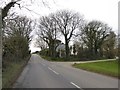
St Allen : Road
A road connects the A30 with the B3285.
Image: © Lewis Clarke
Taken: 22 Oct 2019
0.13 miles
8
A windbreak of palm trees - it must be Cornwall
The bare winter trees show that there is a second windbreak of palms for the garden at the end of the track to Sixty Acres Farm on the right
Image: © David Smith
Taken: 11 Mar 2016
0.16 miles
9
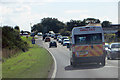
The A30
Traffic approaching the junction at Penny-come-quick. Hope the ambulance isn't in a hurry!
Image: © Robert Ashby
Taken: 18 Aug 2014
0.17 miles
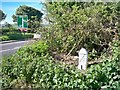
10
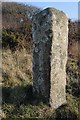
Ancient milestone
This appears to be a milestone though it is not marked on the OS map. It is on Zelah Hill beside the B3285, near its junction with the A30. There a OS benchmark on its side Image
Image: © Philip Halling
Taken: 17 Mar 2016
0.20 miles