IMAGES TAKEN NEAR TO
Zelah, TRURO, TR4 9HY
Introduction
This page details the photographs taken nearby to TR4 9HY by members of the Geograph project.
The Geograph project started in 2005 with the aim of publishing, organising and preserving representative images for every square kilometre of Great Britain, Ireland and the Isle of Man.

There are currently over 7.5m images from over14,400 individuals and you can help contribute to the project by visiting https://www.geograph.org.uk
Image Map
Images are licensed for reuse under creativecommons.org/licenses/by-sa/2.0
Notes
- Clicking on the map will re-center to the selected point.
- The higher the marker number, the further away the image location is from the centre of the postcode.
Image Listing (10 Images Found)
Images are licensed for reuse under creativecommons.org/licenses/by-sa/2.0
Image
Details
Distance
1
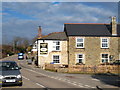
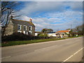
The Hawkins Arms at Zelah
Now a sleepy backwater since the village was by-passed and the A30 moved to the east of its former route here.
Image: © Rod Allday
Taken: 12 Feb 2010
0.05 miles
2
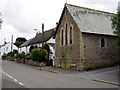
Cottages at Zelah
Cottages and an old chapel on the main street through Zelah, just yards from the busy A30 trunk road.
Image: © Sheila Russell
Taken: 29 Jul 2005
0.05 miles
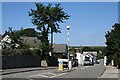
4
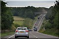
Carrick : The A30
The A30 heads down the hill and back up again as it heads through Cornwall.
Image: © Lewis Clarke
Taken: 1 Jul 2011
0.10 miles

6
Polstain Farm
Beside the old A30 at Zelah.
Image: © Rod Allday
Taken: 12 Feb 2010
0.13 miles
7
Zelah
The main A30 road through Cornwall used to pass through this village until 1991 when a bypass was built but by then the damage was done. The school, churches and shop had all closed. Only a pub remains in what is now a quiet little village.
Image: © Tony Atkin
Taken: 3 Aug 2006
0.14 miles

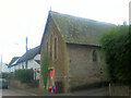
9

Former Methodist Chapel
Built as Wesleyan in 1859, it was extended and had a Sunday School added to the rear in 1868.
Image: © Paul Barnett
Taken: Unknown
0.19 miles
10

St Allen : A30
The A30 heading through the St Allen parish.
Image: © Lewis Clarke
Taken: 22 Oct 2019
0.23 miles