IMAGES TAKEN NEAR TO
Zelah, TRURO, TR4 9HJ
Introduction
This page details the photographs taken nearby to TR4 9HJ by members of the Geograph project.
The Geograph project started in 2005 with the aim of publishing, organising and preserving representative images for every square kilometre of Great Britain, Ireland and the Isle of Man.

There are currently over 7.5m images from over14,400 individuals and you can help contribute to the project by visiting https://www.geograph.org.uk
Image Map
Images are licensed for reuse under creativecommons.org/licenses/by-sa/2.0
Notes
- Clicking on the map will re-center to the selected point.
- The higher the marker number, the further away the image location is from the centre of the postcode.
Image Listing (6 Images Found)
Images are licensed for reuse under creativecommons.org/licenses/by-sa/2.0
Image
Details
Distance
1
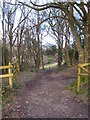
Track through woodland
Leading through a narrow strip of roadside woodland to pastures beyond.
Image: © Rod Allday
Taken: 27 Mar 2010
0.10 miles
2
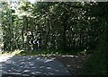
Woodland near Cost-is-lost.
An area of mature broadleaved woodland covers the top of the hill and northern side of the valley here.
Image: © Tony Atkin
Taken: 4 Aug 2006
0.11 miles
3
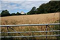
Small Barley Field
Seen on the northern outskirts of Zelah. It is more usual for cereals to be grown in large fields which allow more efficient use of harvesters.
Image: © Tony Atkin
Taken: 4 Aug 2006
0.14 miles
4
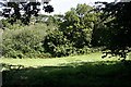
Valley-bottom Meadow
This is a small grass field sandwiched between the usual scrub and woodland around the valley stream and the more substantial woodland on the hillside, out of which the photographer is peering.
Image: © Tony Atkin
Taken: 4 Aug 2006
0.20 miles
5

Old Direction Sign - Signpost by Zelah, St Allen parish
Onion finial - Four arms missing; Sara and Burgess by the UC road, in parish of St Allen (Carrick District), Zelah (Cost-is-Lost), on Southeast bank of crossroads.
Restored by 2019.
Grade II listed.
List Entry Number: 1141580 https://historicengland.org.uk/listing/the-list/list-entry/1141580
Surveyed
Milestone Society National ID: CW_SW8051
Image: © Milestone Society
Taken: Unknown
0.22 miles
6
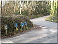
Water main signs by the junction at Cost-is-Lost
WO is wash out and SV is stop valve.
Image: © Rod Allday
Taken: 12 Feb 2010
0.22 miles