IMAGES TAKEN NEAR TO
Newberry Lane, TRURO, TR4 9FE
Introduction
This page details the photographs taken nearby to Newberry Lane, TR4 9FE by members of the Geograph project.
The Geograph project started in 2005 with the aim of publishing, organising and preserving representative images for every square kilometre of Great Britain, Ireland and the Isle of Man.

There are currently over 7.5m images from over14,400 individuals and you can help contribute to the project by visiting https://www.geograph.org.uk
Image Map
Images are licensed for reuse under creativecommons.org/licenses/by-sa/2.0
Notes
- Clicking on the map will re-center to the selected point.
- The higher the marker number, the further away the image location is from the centre of the postcode.
Image Listing (4 Images Found)
Images are licensed for reuse under creativecommons.org/licenses/by-sa/2.0
Image
Details
Distance
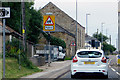
1
Junction of the minor road from Henrda Croft with the A3075
Image: © Rod Allday
Taken: 10 Nov 2013
0.08 miles
3
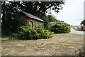
Entrance to a Holiday Park
The building to the left, at the entrance to the New Perran Holiday Park is a curious small-scale mock-up of an old building. Only the front half exists, there is no back to it at all.
Image: © Tony Atkin
Taken: 4 Aug 2006
0.19 miles