IMAGES TAKEN NEAR TO
Kenwyn, TRURO, TR4 9ET
Introduction
This page details the photographs taken nearby to TR4 9ET by members of the Geograph project.
The Geograph project started in 2005 with the aim of publishing, organising and preserving representative images for every square kilometre of Great Britain, Ireland and the Isle of Man.

There are currently over 7.5m images from over14,400 individuals and you can help contribute to the project by visiting https://www.geograph.org.uk
Image Map
Images are licensed for reuse under creativecommons.org/licenses/by-sa/2.0
Notes
- Clicking on the map will re-center to the selected point.
- The higher the marker number, the further away the image location is from the centre of the postcode.
Image Listing (7 Images Found)
Images are licensed for reuse under creativecommons.org/licenses/by-sa/2.0
Image
Details
Distance
1
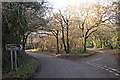
Minor Road Junction below Shortlanesend
The barn like structure which can be glimpsed behind the trees is actually a very modern house.
Image: © Tony Atkin
Taken: 10 Dec 2005
0.04 miles
2
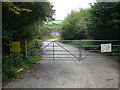
Entrance to the substation at Bussavean
The substation grounds are completely surrounded by the Watts Nature Reserve, managed by Cornwall Wildlife Trust.
Image: © Rod Allday
Taken: 9 Oct 2009
0.11 miles
3
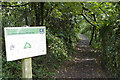
Watts Nature Reserve entrance
This footpath leads into the Watts Nature Reserve, managed by the Cornwall Wildlife Trust.
Image: © Elizabeth Scott
Taken: 19 Sep 2013
0.12 miles
4
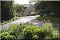
Entrance to Penrose Water Gardens
Entrance to Penrose Water Gardens and Great Roseveth.
Image: © Elizabeth Scott
Taken: 19 Sep 2013
0.13 miles
5
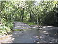
Ford on a tributary of the River Kenwyn at Lower Bosvean
Image: © Rod Allday
Taken: 7 Aug 2008
0.15 miles
6
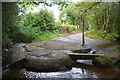
Roseworthy Ford
This interesting ford at Roseworthy is found beside Penrose Water Gardens.
Image: © John Walton
Taken: 23 Sep 2015
0.15 miles
7
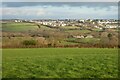
Pastures, Kenwyn
A bungalow called Upton Rise and the village of Shortlanesend are viewed from the bridleway above Little Roseveth Farm.
Image: © Andrew Smith
Taken: 16 Jan 2022
0.19 miles