IMAGES TAKEN NEAR TO
Tregavethan, TRURO, TR4 9EP
Introduction
This page details the photographs taken nearby to TR4 9EP by members of the Geograph project.
The Geograph project started in 2005 with the aim of publishing, organising and preserving representative images for every square kilometre of Great Britain, Ireland and the Isle of Man.

There are currently over 7.5m images from over14,400 individuals and you can help contribute to the project by visiting https://www.geograph.org.uk
Image Map
Images are licensed for reuse under creativecommons.org/licenses/by-sa/2.0
Notes
- Clicking on the map will re-center to the selected point.
- The higher the marker number, the further away the image location is from the centre of the postcode.
Image Listing (7 Images Found)
Images are licensed for reuse under creativecommons.org/licenses/by-sa/2.0
Image
Details
Distance
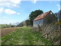
1
Causilgey from Tregavethan
Causilgey Farm. Taken from the field entrance near Tregavethan Manor in square SW7847, using the telephoto end of my lens.
Image: © Elizabeth Scott
Taken: 17 Oct 2013
0.05 miles
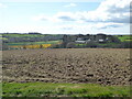
2
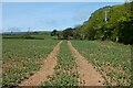
Farmland, Kenwyn
A crop of beans to the west of Causilgey.
Image: © Andrew Smith
Taken: 7 May 2022
0.09 miles
3
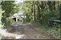
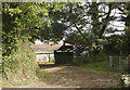
Entrance to Causilgey Farm
Causilgey Farm entrance track.
Image: © Elizabeth Scott
Taken: 17 Oct 2013
0.10 miles
4
Barn at Causilgey
Looking through the trees to the barn at Causilgey.
Image: © Elizabeth Scott
Taken: 17 Oct 2013
0.11 miles
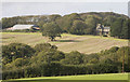
5
Looking across the fields towards Causilgey
Image: © Rod Allday
Taken: 27 Mar 2023
0.12 miles
6
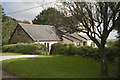
Causilgey Cottage
Modern dwelling at Causilgey.
Image: © Elizabeth Scott
Taken: 17 Oct 2013
0.19 miles