IMAGES TAKEN NEAR TO
Tregavethan, TRURO, TR4 9EJ
Introduction
This page details the photographs taken nearby to TR4 9EJ by members of the Geograph project.
The Geograph project started in 2005 with the aim of publishing, organising and preserving representative images for every square kilometre of Great Britain, Ireland and the Isle of Man.

There are currently over 7.5m images from over14,400 individuals and you can help contribute to the project by visiting https://www.geograph.org.uk
Image Map
Images are licensed for reuse under creativecommons.org/licenses/by-sa/2.0
Notes
- Clicking on the map will re-center to the selected point.
- The higher the marker number, the further away the image location is from the centre of the postcode.
Image Listing (4 Images Found)
Images are licensed for reuse under creativecommons.org/licenses/by-sa/2.0
Image
Details
Distance
1
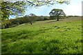
Pasture, Kenwyn
Beside the bridleway east of Penponds.
Image: © Andrew Smith
Taken: 7 May 2022
0.16 miles
2
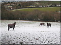
Horses in a snow covered field at Tregavethan
Snow is a rare occurrence here in the far south west but in late November 2010 there was unusually extreme cold weather, with snow lying on the ground for several days.
Image: © Rod Allday
Taken: 3 Dec 2010
0.16 miles
3
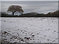
A snow covered field at Bosvisack
Snow has been lying for nearly a week in unusually extreme cold weather in late November/early December.
Image: © Rod Allday
Taken: 3 Dec 2010
0.23 miles
4
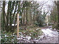
Public bridleway at Tregavethan
Leading towards Treworder.
Image: © Rod Allday
Taken: 3 Dec 2010
0.24 miles