IMAGES TAKEN NEAR TO
Allet, TRURO, TR4 9DP
Introduction
This page details the photographs taken nearby to TR4 9DP by members of the Geograph project.
The Geograph project started in 2005 with the aim of publishing, organising and preserving representative images for every square kilometre of Great Britain, Ireland and the Isle of Man.

There are currently over 7.5m images from over14,400 individuals and you can help contribute to the project by visiting https://www.geograph.org.uk
Image Map
Images are licensed for reuse under creativecommons.org/licenses/by-sa/2.0
Notes
- Clicking on the map will re-center to the selected point.
- The higher the marker number, the further away the image location is from the centre of the postcode.
Image Listing (5 Images Found)
Images are licensed for reuse under creativecommons.org/licenses/by-sa/2.0
Image
Details
Distance
2
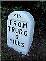
Old Milestone by the B3284, east of Allet
Carved stone post by the B3284, in parish of KENWYN (CARRICK District), Allet, West of village sign, set in bank at road edge, on South side of road. Truro stone, erected by the Truro turnpike trust in the 18th century.
Inscription reads:-
FROM
TRURO
3
MILES
Carved benchmark on top of front face.
Grade II Listed. List Entry Number:1140925
https://historicengland.org.uk/listing/the-list/list-entry/1140925
Milestone Society National ID: CW_TOPP03.
Image: © Ian Thompson
Taken: 1 May 2003
0.07 miles
3
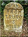
Old Milestone by the B3284, east of Allet
Carved stone post by the B3284, in parish of KENWYN (CARRICK District), Allet, West of village sign, set in bank at road edge, on South side of road. Truro stone, erected by the Truro turnpike trust in the 18th century.
Inscription reads:-
FROM
TRURO
3
MILES
Carved benchmark on top of front face.
Grade II listed.
List Entry Number: 1140925 https://historicengland.org.uk/listing/the-list/list-entry/1140925
Milestone Society National ID: CW_TOPP03.
Image: © Rosy Hanns
Taken: 18 May 2019
0.07 miles
4
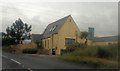
Possible former chapel
Between Allet and Shortlanesend
Image: © Paul Barnett
Taken: 20 Oct 2015
0.10 miles
5
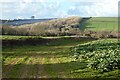
Farmland, Kenwyn
A bridleway to the east of Allet passes between fields of cauliflowers with an array of solar panels visible in the background.
Image: © Andrew Smith
Taken: 4 Mar 2022
0.18 miles