IMAGES TAKEN NEAR TO
Ennis Close, TRURO, TR4 9BU
Introduction
This page details the photographs taken nearby to Ennis Close, TR4 9BU by members of the Geograph project.
The Geograph project started in 2005 with the aim of publishing, organising and preserving representative images for every square kilometre of Great Britain, Ireland and the Isle of Man.

There are currently over 7.5m images from over14,400 individuals and you can help contribute to the project by visiting https://www.geograph.org.uk
Image Map
Images are licensed for reuse under creativecommons.org/licenses/by-sa/2.0
Notes
- Clicking on the map will re-center to the selected point.
- The higher the marker number, the further away the image location is from the centre of the postcode.
Image Listing (16 Images Found)
Images are licensed for reuse under creativecommons.org/licenses/by-sa/2.0
Image
Details
Distance
1

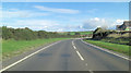
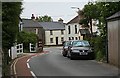
Trispen village
A peaceful scene now that the A39 by-passes the village.
Image: © Rod Allday
Taken: 19 Oct 2008
0.06 miles
3
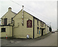
The Clock & Key, Trispen
The pub is 'brown signed' from the A39.
Image: © Stuart Logan
Taken: 7 Oct 2012
0.11 miles
4
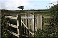
Kissing Gate to Cross the Road
The footpath from Trispen to St Allen crosses the A39 road just beyond this gate. If you can get across this section safely then walking the rest of the path offers no danger.
Image: © Tony Atkin
Taken: 1 Sep 2006
0.11 miles
5
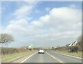
Trispen Village Centre
The red tarmacked area on the left hand side of the road is useful for walkers and cyclists as there is no pavement. However, when cars park on the other side and force motorists to invade the red area just to get by then it all seems like a waste of money.
Image: © Tony Atkin
Taken: 10 Jun 2006
0.12 miles
6
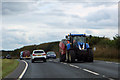
King of the road
A large tractor on the A39 at Trispen.
Image: © Robert Ashby
Taken: 21 Aug 2014
0.16 miles
8
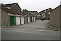
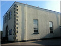
Modern Housing in St Erme
This estate separates garages from their houses. This was quite a popular concept with the designers of late 20th century housing estates. It requires fewer roads to be built into the estate and allows a higher density of housing. It was marketed as providing a more pleasant environment.
Image: © Tony Atkin
Taken: 10 Jun 2006
0.21 miles
9
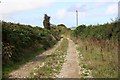
Footpath and Farm Track
The footpath from Trispen to St Allen is wide and clear at this point, being obviously regularly used by farm vehicles.
Image: © Tony Atkin
Taken: 1 Sep 2006
0.22 miles