IMAGES TAKEN NEAR TO
Penmount, TRURO, TR4 9AA
Introduction
This page details the photographs taken nearby to TR4 9AA by members of the Geograph project.
The Geograph project started in 2005 with the aim of publishing, organising and preserving representative images for every square kilometre of Great Britain, Ireland and the Isle of Man.

There are currently over 7.5m images from over14,400 individuals and you can help contribute to the project by visiting https://www.geograph.org.uk
Image Map
Images are licensed for reuse under creativecommons.org/licenses/by-sa/2.0
Notes
- Clicking on the map will re-center to the selected point.
- The higher the marker number, the further away the image location is from the centre of the postcode.
Image Listing (7 Images Found)
Images are licensed for reuse under creativecommons.org/licenses/by-sa/2.0
Image
Details
Distance
1
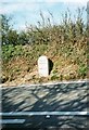
Old Milestone by the A39, opposite Calerick
Carved stone post by the A39 (was A3076), in parish of ST CLEMENT (CARRICK District), Calerick, Truro side of sharp bend, in bank, on West side of road. Truro stone, erected by the Truro turnpike trust in the 18th century.
Inscription reads:-
FROM
TRURO
2
MILES
Carved benchmark on front face.
Grade II Listed. List Entry Number:1396479
https://historicengland.org.uk/listing/the-list/list-entry/1396479
Milestone Society National ID: CW_TOMI02.
Image: © Ian Thompson
Taken: 1 Apr 1996
0.16 miles
2
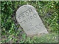
Old Milestone by the A39, opposite Calerick
Carved stone post by the A39 (was A3076), in parish of ST CLEMENT (CARRICK District), Calerick, Truro side of sharp bend, in bank, on West side of road. Truro stone, erected by the Truro turnpike trust in the 18th century.
Inscription reads:-
FROM
TRURO
2
MILES
Carved benchmark on front face.
(Stone has since been re-erected)
Grade II listed.
List Entry Number: 1396479 https://historicengland.org.uk/listing/the-list/list-entry/1396479
Milestone Society National ID: CW_TOMI02.
Image: © Rosy Hanns
Taken: 5 May 2019
0.17 miles
3
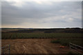
Cornwall : Grassy Field
From the road looking into a field.
Image: © Lewis Clarke
Taken: 19 Apr 2017
0.17 miles
4
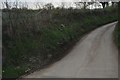
Cornwall : Country Lane
A small road off of the A39.
Image: © Lewis Clarke
Taken: 19 Apr 2017
0.17 miles
5
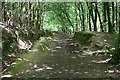
Woodland Path
This woodland path goes through an area of woodland marked as St Clement's Wood on the map although I believe this whole woodland area is more commonly known as Idless Woods after the hamlet which is close to the car park.
Image: © Tony Atkin
Taken: 23 Jul 2006
0.22 miles
6
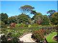
The rose garden at Penmount crematorium
Part of the beautiful formal gardens at the crematorium - still quite colourful in October.
Image: © Rod Allday
Taken: 8 Oct 2009
0.24 miles
7
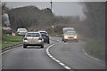
Carrick : The A39
Looking along the A39 near Truro.
Image: © Lewis Clarke
Taken: 23 Feb 2012
0.25 miles