IMAGES TAKEN NEAR TO
Bissoe, TRURO, TR4 8TF
Introduction
This page details the photographs taken nearby to TR4 8TF by members of the Geograph project.
The Geograph project started in 2005 with the aim of publishing, organising and preserving representative images for every square kilometre of Great Britain, Ireland and the Isle of Man.

There are currently over 7.5m images from over14,400 individuals and you can help contribute to the project by visiting https://www.geograph.org.uk
Image Map
Images are licensed for reuse under creativecommons.org/licenses/by-sa/2.0
Notes
- Clicking on the map will re-center to the selected point.
- The higher the marker number, the further away the image location is from the centre of the postcode.
Image Listing (4 Images Found)
Images are licensed for reuse under creativecommons.org/licenses/by-sa/2.0
Image
Details
Distance
1

Entrance to Wheal Jane
A mining locomotive at the entrance to the former mine which closed in 1992, and is now home to a range of mining-related companies.
Image: © Derek Harper
Taken: 1 May 2009
0.11 miles
2

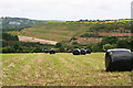
Lane to Bissoe
The lane from Wheal Baddon drops down the northern slopes of the Carnon River valley.
Image: © Derek Harper
Taken: 1 May 2009
0.17 miles
3
The Wheal Jane Tailings Dam
When Wheal Jane was in operation this dam enclosed settling lagoons where water pumped from the mine was treated with lime and left to settle before being released into the river.
Image: © Tony Atkin
Taken: 14 Jun 2008
0.18 miles
4
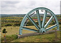
Welcome to Wheal Jane
This welcome sign wrapped around half of an old winding wheel is at the eastern entrance to the disused Wheal Jane site which now houses several companies in the mining, minerals, environment and engineering industries. Behind the sign, beyond the mown field is the level expanse of the tailings lagoons.
Image: © Tony Atkin
Taken: 14 Jun 2008
0.19 miles