IMAGES TAKEN NEAR TO
Pencantol, TRURO, TR4 8SQ
Introduction
This page details the photographs taken nearby to Pencantol, TR4 8SQ by members of the Geograph project.
The Geograph project started in 2005 with the aim of publishing, organising and preserving representative images for every square kilometre of Great Britain, Ireland and the Isle of Man.

There are currently over 7.5m images from over14,400 individuals and you can help contribute to the project by visiting https://www.geograph.org.uk
Image Map
Images are licensed for reuse under creativecommons.org/licenses/by-sa/2.0
Notes
- Clicking on the map will re-center to the selected point.
- The higher the marker number, the further away the image location is from the centre of the postcode.
Image Listing (10 Images Found)
Images are licensed for reuse under creativecommons.org/licenses/by-sa/2.0
Image
Details
Distance
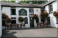
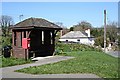
1
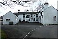
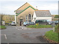
The Cornish Arms, Frogpool
New licensee summer 2010.
Not an extensive menu but what was served was perfectly cooked and very good value for money.
Image: © Fred James
Taken: 20 Feb 2007
0.05 miles
2
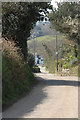
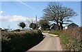
Into the village
Looking down into the village from the east, showing The Cornish Arms in the distance
Image: © Phillip Roscorla
Taken: 7 Apr 2007
0.06 miles
3
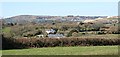
View From Frogpool
Looking west to Carn Marth on the left and the United Downs Landfill Site on the right of the picture.
Image: © Tony Atkin
Taken: 6 Apr 2006
0.07 miles
8
East of Frogpool
Houses and bales of hay wrapped in blue plastic.
Image: © Tony Atkin
Taken: 6 Apr 2006
0.16 miles
10
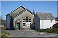
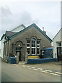
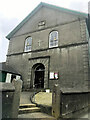
Frogpool Methodist Church
A Methodist Church which is still used for its original purpose.
Image: © Tony Atkin
Taken: 6 Apr 2006
0.20 miles