IMAGES TAKEN NEAR TO
Cusvey, TRURO, TR4 8SP
Introduction
This page details the photographs taken nearby to Cusvey, TR4 8SP by members of the Geograph project.
The Geograph project started in 2005 with the aim of publishing, organising and preserving representative images for every square kilometre of Great Britain, Ireland and the Isle of Man.

There are currently over 7.5m images from over14,400 individuals and you can help contribute to the project by visiting https://www.geograph.org.uk
Image Map
Images are licensed for reuse under creativecommons.org/licenses/by-sa/2.0
Notes
- Clicking on the map will re-center to the selected point.
- The higher the marker number, the further away the image location is from the centre of the postcode.
Image Listing (9 Images Found)
Images are licensed for reuse under creativecommons.org/licenses/by-sa/2.0
Image
Details
Distance
1
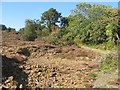
Spoil heap by the track
Mining spoil by the side of this track appears to be a 'work in progress', picked over by curious folk (like me). This appears to be part of the Cusvey Mine, but such details are not easy to confirm.
Image: © Jonathan Wilkins
Taken: 20 Sep 2019
0.07 miles
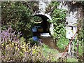
2
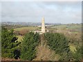
Engine house at Cusvey
Surrounded with scaffolding for stabilisation works being carried out.
Image: © Rod Allday
Taken: 19 Nov 2008
0.09 miles
4
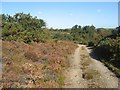
Track on heath
Areas of heathland amid otherwise verdant pasture indicate a substrate of mining waste. The oxidation of sulphide ores acidifies the soil, while metals and arsenic which are liberated deter most plant growth. Heather, lichen and mosses are just about the only vegetation that will tolerate such conditions. The chimney of an engine house from the Cusvey Mine peeps over the treetops.
Image: © Jonathan Wilkins
Taken: 20 Sep 2019
0.13 miles
5
Bridge over the Carnon River
This bridge carried the Redruth and Chasewater Railway that opened in 1825 to link the mining areas of Gwenap and St Day with the port of Devoran. It was also intended to link Chacewater but that section was never completed.
The line closed in 1915.
Image: © Fred James
Taken: 3 Sep 2007
0.17 miles
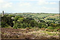
6
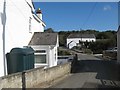
Twelveheads bridge and chapel
The village of Twelveheads is apparently named for the crushing mill, or stamps which operated here to break down the tin ores. This view looks over the bridge towards the Methodist chapel.
Image: © Jonathan Wilkins
Taken: 20 Sep 2019
0.22 miles
7
Bread and Cheese Shaft, Nangiles
Adjacent to both the lane and the public bridleway, this open shaft on Nangiles Mine, near to Wheal Edward, is named after the Bread and Cheese mineral lode which traverses the mine sett at this point.
Image: © John Gibson
Taken: 17 Mar 2009
0.23 miles
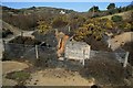
9
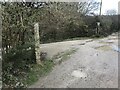
Two Boundary Markers in the Poldice Valley
Two Mine Boundary Markers beside a track inside a mining area in the Poldice Valley. On the left is Milestone Society National ID: CW_GWECHA80em and on the right is Milestone Society National ID: CW_GWECHA81em. On the current boundary between Gwennap and Chacewater parishes. These stones not only define the parish boundary but also the mineral rights of local landowners.
Image: © P Barnett
Taken: 9 Feb 2024
0.24 miles