IMAGES TAKEN NEAR TO
Woodside Paddock, TRURO, TR4 8RR
Introduction
This page details the photographs taken nearby to Woodside Paddock, TR4 8RR by members of the Geograph project.
The Geograph project started in 2005 with the aim of publishing, organising and preserving representative images for every square kilometre of Great Britain, Ireland and the Isle of Man.

There are currently over 7.5m images from over14,400 individuals and you can help contribute to the project by visiting https://www.geograph.org.uk
Image Map
Images are licensed for reuse under creativecommons.org/licenses/by-sa/2.0
Notes
- Clicking on the map will re-center to the selected point.
- The higher the marker number, the further away the image location is from the centre of the postcode.
Image Listing (53 Images Found)
Images are licensed for reuse under creativecommons.org/licenses/by-sa/2.0
Image
Details
Distance
1
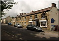
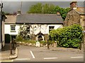
The Rambling Miner, Chacewater (2)
A view of Image together with the C19 cottages adjoining it to the west, which are described at http://www.imagesofengland.org.uk/Details/Default.aspx?id=63171&mode=adv and http://www.imagesofengland.org.uk/Details/Default.aspx?id=63172&mode=adv .
Image: © Derek Harper
Taken: 18 May 2009
0.04 miles
2
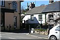
The Rambling Miner, Chacewater
This pub, with its little Doric porch, is at the western end of the village. http://www.imagesofengland.org.uk/Details/Default.aspx?id=63173&mode=adv . See also Image
Image: © Derek Harper
Taken: 18 May 2009
0.04 miles
4
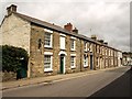
Cottages on Fore Street, Chacewater
The old milestone by the roadside tells us that we are 5 miles from Truro.
Image: © Tony Atkin
Taken: 6 Apr 2006
0.05 miles
5
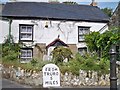
Terrace, Chacewater
This row of cottages is to the east of Image The nearest preserves its original 16-pane sash windows. http://www.imagesofengland.org.uk/Details/Default.aspx?id=63174&mode=adv
Image: © Derek Harper
Taken: 18 May 2009
0.05 miles
6
Cottages in Chacewater
An alternative view of the scene in Image The mid-C19 cottage on the left has its original 16-pane sash windows. http://www.imagesofengland.org.uk/Details/Default.aspx?id=63160&mode=adv
Image: © Derek Harper
Taken: 18 May 2009
0.07 miles
7
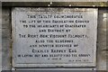
Old Milestone by the former A390, Fore Street, Chacewater
Carved stone post by the UC road (was A390), in parish of CHACEWATER (CARRICK District), Fore Street, No. 23, built into garden wall of cottage, on North side of road. Truro stone, erected by the Truro turnpike trust in the 18th century.
Inscription reads:-
FROM
TRURO
5
MILES
Grade II Listed. List Entry Number:1140961
https://historicengland.org.uk/listing/the-list/list-entry/1140961
Milestone Society National ID: CW_TORR05.
Image: © Ian Thompson
Taken: 1 Feb 2004
0.07 miles
8
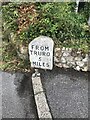
Old Milestone by UC road (was A390), Fore Street, No 23
The Milestone is located built into garden wall of cottage on the North of the road. Parish of Chacewater (Carrick District). Carved stone post, Truro stone design, erected by the Truro turnpike trust in the 18th Century, minor edge chips. An earlier photograph can be found here: https://www.geograph.org.uk/photo/5623645
Inscription reads:-
FROM / TRURO / 5 / MILES
Grade II listed. List Entry Number: 1140961 https://historicengland.org.uk/listing/the-list/list-entry/1140961
Milestone Society National ID: CW_TORR05
Image: © Paul Barnett
Taken: 11 Jul 2023
0.07 miles
9
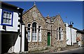
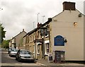
Chacewater Literary Institute
Opened in 1893, this is another of the many such buildings in Cornwall financed by John Passmore Edwards. It is no longer used for its original purpose. Chacewater is visited by a mobile library truck once a week.
Image: © Tony Atkin
Taken: 6 Apr 2006
0.08 miles
10
Chacewater Recreation Ground plaque
Plaque at the entrance to the recreation ground. See also Image
Image: © Elizabeth Scott
Taken: 25 Sep 2023
0.08 miles