IMAGES TAKEN NEAR TO
Cusgarne, TRURO, TR4 8RG
Introduction
This page details the photographs taken nearby to TR4 8RG by members of the Geograph project.
The Geograph project started in 2005 with the aim of publishing, organising and preserving representative images for every square kilometre of Great Britain, Ireland and the Isle of Man.

There are currently over 7.5m images from over14,400 individuals and you can help contribute to the project by visiting https://www.geograph.org.uk
Image Map
Images are licensed for reuse under creativecommons.org/licenses/by-sa/2.0
Notes
- Clicking on the map will re-center to the selected point.
- The higher the marker number, the further away the image location is from the centre of the postcode.
Image Listing (6 Images Found)
Images are licensed for reuse under creativecommons.org/licenses/by-sa/2.0
Image
Details
Distance
1
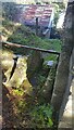
Stone Stile SW7640a
Chycoose Farm
A granite stile of steps with an iron bar horizontally across the top.
Public footpath 307/32/2 (silver) at Chycoose Farm. Footpath runs from Footpath 307/34/2 & Byway 307/34/1 to join up with 307/33/1 & 307/32/1 at Lanner farm.
Image: © Carrie Langford
Taken: 14 Oct 2021
0.10 miles
2
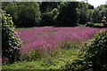
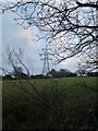
Field near Hicks Mill
A profusion of red campions
Image: © Fred James
Taken: 2 Jun 2010
0.16 miles
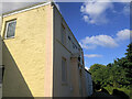
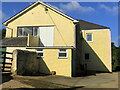
3
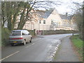
Cusgarne CP School
Quite a large school for such a small settlement but presumably it draws from all the other villages and hamlets around.
Image: © Rod Allday
Taken: 16 Dec 2009
0.20 miles