IMAGES TAKEN NEAR TO
Chacewater, TRURO, TR4 8QT
Introduction
This page details the photographs taken nearby to TR4 8QT by members of the Geograph project.
The Geograph project started in 2005 with the aim of publishing, organising and preserving representative images for every square kilometre of Great Britain, Ireland and the Isle of Man.

There are currently over 7.5m images from over14,400 individuals and you can help contribute to the project by visiting https://www.geograph.org.uk
Image Map
Images are licensed for reuse under creativecommons.org/licenses/by-sa/2.0
Notes
- Clicking on the map will re-center to the selected point.
- The higher the marker number, the further away the image location is from the centre of the postcode.
Image Listing (54 Images Found)
Images are licensed for reuse under creativecommons.org/licenses/by-sa/2.0
Image
Details
Distance
1
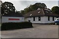
Chacewater Health Centre
Chacewater GP Surgery.
Image: © Elizabeth Scott
Taken: 25 Sep 2023
0.04 miles
2
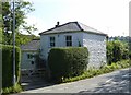
Chacewater Tollhouse by Church Hill, Chacewater
Tollhouse in the parish of St Day (Carrick District), Toll Cottage, Church Hill, Chacewater, TR4 8PZ.
Surveyed
Milestone Society National ID: CW.STD01
Image: © Alan Rosevear
Taken: 10 Sep 2014
0.05 miles
3
Chacewater Village Hall
The Village Hall looks very well appointed, a useful community resource.
Image: © Elizabeth Scott
Taken: 25 Sep 2023
0.05 miles
4
Chacewater Millennium Green
The Millennium Green is a public space behind the Village Hall. See also Image
Image: © Elizabeth Scott
Taken: 25 Sep 2023
0.05 miles
5
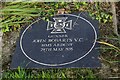
Memorial Stone to John Robarts VC
This memorial stone to John Robarts VC is at the entrance to the Millennium Green. He was born nearby at Wheal Busy and initially worked as a miner, but joined the Royal Navy in 1842. He was awarded the Victoria Cross for his bravery while serving as a Gunner aboard HMS Ardent during the Crimean War. See also Image
Image: © Elizabeth Scott
Taken: 25 Sep 2023
0.05 miles
6
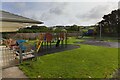
Chacewater Recreation Ground
Children's play area in the recreation ground. See also Image
Image: © Elizabeth Scott
Taken: 25 Sep 2023
0.07 miles
7
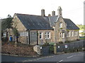
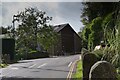
Chacewater CP School
Originally a National School, built in 1847.
Image: © Rod Allday
Taken: 19 Nov 2008
0.08 miles
8
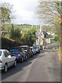
Church Hill Chacewater
Leading from the church down into the village. Chacewater CP School on the left-hand side.
Image: © Rod Allday
Taken: 19 Nov 2008
0.08 miles
9
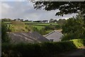
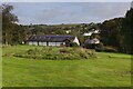
View to the opposite side of the valley
The minor road from Chacewater to Twelveheads follows the Carnon River Valley. This is the view across the valley from the minor road as it leaves Chacewater.
Image: © Elizabeth Scott
Taken: 3 Oct 2023
0.09 miles
10
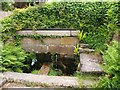
The Shute, Chacewater
A plaque commemorates the fact that until the mid 1950s, this was the village's drinking water supply. This is beside footpath 301/18/1, which runs down the Carnon valley from Fore Street.
Image: © Derek Harper
Taken: 18 May 2009
0.09 miles