IMAGES TAKEN NEAR TO
Greenbottom, TRURO, TR4 8QJ
Introduction
This page details the photographs taken nearby to Greenbottom, TR4 8QJ by members of the Geograph project.
The Geograph project started in 2005 with the aim of publishing, organising and preserving representative images for every square kilometre of Great Britain, Ireland and the Isle of Man.

There are currently over 7.5m images from over14,400 individuals and you can help contribute to the project by visiting https://www.geograph.org.uk
Image Map
Images are licensed for reuse under creativecommons.org/licenses/by-sa/2.0
Notes
- Clicking on the map will re-center to the selected point.
- The higher the marker number, the further away the image location is from the centre of the postcode.
Image Listing (9 Images Found)
Images are licensed for reuse under creativecommons.org/licenses/by-sa/2.0
Image
Details
Distance
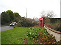
1
Bus stop on the road to Chacewater
Although this is an unclassified road, it is a very busy one, as it offers an alternative route from Redruth to Truro to the A30/A390 option.
Image: © Rod Allday
Taken: 16 Dec 2009
0.04 miles
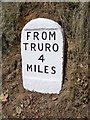
4
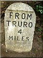
Old Milestone by the former A390, near Saveock
Carved stone post by the UC road (was A390), in parish of KENWYN (CARRICK District), Saveock, Green Bottom, set into bank by road at foot of house drive, on North side of road. Truro stone, erected by the Truro turnpike trust in the 18th century.
Inscription reads:-
FROM
TRURO
4
MILES
Grade II listed.
List Entry Number: 1140889 https://historicengland.org.uk/listing/the-list/list-entry/1140889
Milestone Society National ID: CW_TORR04.
Image: © Rosy Hanns
Taken: 5 Jul 2019
0.13 miles
5
Old Milestone by the former A390, near Saveock
Carved stone post by the UC road (was A390), in parish of KENWYN (CARRICK District), Saveock, Green Bottom, set into bank by road at foot of house drive, on North side of road. Truro stone, erected by the Truro turnpike trust in the 18th century.
Inscription reads:-
FROM
TRURO
4
MILES
Grade II Listed. List Entry Number:1140889
https://historicengland.org.uk/listing/the-list/list-entry/1140889
Milestone Society National ID: CW_TORR04.
Image: © Ian Thompson
Taken: 1 Feb 2004
0.13 miles
7
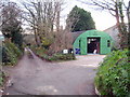
Entrance to the West of England Sack Company premises
Well tucked away down a lane at Greenbottom.
Image: © Rod Allday
Taken: 16 Dec 2009
0.18 miles
9
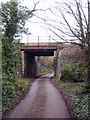
Greenbottom railway bridge
Carrying the Penzance-Paddington mainline over a minor track.
Image: © Rod Allday
Taken: 16 Dec 2009
0.24 miles