IMAGES TAKEN NEAR TO
Penstraze, TRURO, TR4 8PN
Introduction
This page details the photographs taken nearby to Penstraze, TR4 8PN by members of the Geograph project.
The Geograph project started in 2005 with the aim of publishing, organising and preserving representative images for every square kilometre of Great Britain, Ireland and the Isle of Man.

There are currently over 7.5m images from over14,400 individuals and you can help contribute to the project by visiting https://www.geograph.org.uk
Image Map
Images are licensed for reuse under creativecommons.org/licenses/by-sa/2.0
Notes
- Clicking on the map will re-center to the selected point.
- The higher the marker number, the further away the image location is from the centre of the postcode.
Image Listing (4 Images Found)
Images are licensed for reuse under creativecommons.org/licenses/by-sa/2.0
Image
Details
Distance
1

Field at Higher Deer Park Farm
Looking across a small valley towards Truro Airfield, whose orange windsock is just visible on the horizon.
Image: © Rod Allday
Taken: 3 Dec 2010
0.22 miles
2
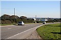
The Road to Truro
Looking towards Rosewinnick Farm.
Image: © Tony Atkin
Taken: 4 Nov 2006
0.22 miles
3

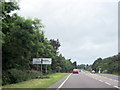
A390 near Primrose Farm entrance
Approaching staggered junction at Penstraze
Image: © John Firth
Taken: 13 Jun 2014
0.25 miles