IMAGES TAKEN NEAR TO
Penstraze, TRURO, TR4 8PL
Introduction
This page details the photographs taken nearby to Penstraze, TR4 8PL by members of the Geograph project.
The Geograph project started in 2005 with the aim of publishing, organising and preserving representative images for every square kilometre of Great Britain, Ireland and the Isle of Man.

There are currently over 7.5m images from over14,400 individuals and you can help contribute to the project by visiting https://www.geograph.org.uk
Image Map
Images are licensed for reuse under creativecommons.org/licenses/by-sa/2.0
Notes
- Clicking on the map will re-center to the selected point.
- The higher the marker number, the further away the image location is from the centre of the postcode.
Image Listing (5 Images Found)
Images are licensed for reuse under creativecommons.org/licenses/by-sa/2.0
Image
Details
Distance
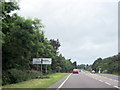
1

A390 near Primrose Farm entrance
Approaching staggered junction at Penstraze
Image: © John Firth
Taken: 13 Jun 2014
0.08 miles
3
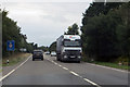
The A39
Heading north-west out of Truro.
Image: © Robert Ashby
Taken: 21 Aug 2014
0.14 miles
4
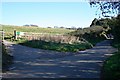
Country Lane
The gateway on the left is the entrance to Truro Airfield, a small private airstrip.
Image: © Tony Atkin
Taken: 4 Nov 2006
0.21 miles
5
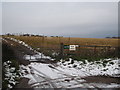
The entrance to Truro Airfield
Truro Airfield (call sign EGHY) is about as basic as it gets - just two grass landing strips - one 500m and one 290m http://www.pilotfriend.com/UK_airfields/airfields/EGHY%20TRURO.htm
Image: © Rod Allday
Taken: 3 Dec 2010
0.25 miles