IMAGES TAKEN NEAR TO
Brewery Court, TRURO, TR4 8PD
Introduction
This page details the photographs taken nearby to Brewery Court, TR4 8PD by members of the Geograph project.
The Geograph project started in 2005 with the aim of publishing, organising and preserving representative images for every square kilometre of Great Britain, Ireland and the Isle of Man.

There are currently over 7.5m images from over14,400 individuals and you can help contribute to the project by visiting https://www.geograph.org.uk
Image Map
Images are licensed for reuse under creativecommons.org/licenses/by-sa/2.0
Notes
- Clicking on the map will re-center to the selected point.
- The higher the marker number, the further away the image location is from the centre of the postcode.
Image Listing (38 Images Found)
Images are licensed for reuse under creativecommons.org/licenses/by-sa/2.0
Image
Details
Distance
1
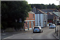
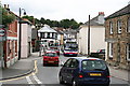
In Chacewater
Between Truro and Redruth.
Image: © Robert Ashby
Taken: 19 Aug 2014
0.04 miles
4
Chacewater Village Store
Another distinctive shopfront, see also Image
Image: © Elizabeth Scott
Taken: 25 Sep 2023
0.06 miles
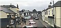
5
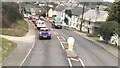
Fore Street Chacewater with Buses
Fore Street is the main road through Chacewater and the main shopping street of this large village. Traffic congestion seems to be the norm here and two buses taking on passengers do little to help. Chacewater is on the main bus route between Truro and Redruth and has a bus every 10 minutes in both directions - a level of service which would make many urban dwellers envious.
Image: © Tony Atkin
Taken: 14 Jun 2008
0.06 miles
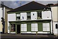
6
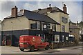
The King's Head
Public house also providing accommodation.
Image: © Elizabeth Scott
Taken: 25 Sep 2023
0.06 miles
7
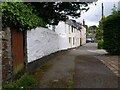
East Bridge, Chacewater
A row of five cottages beside this lane carrying footpath 301/18/1 to meet Fore Street.
Image: © Derek Harper
Taken: 18 May 2009
0.06 miles
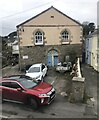
9
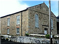
Former Wesleyan Chapel
Now converted to residential use.
Image: © Paul Barnett
Taken: 7 May 2014
0.07 miles
10
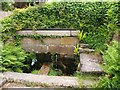
The Shute, Chacewater
A plaque commemorates the fact that until the mid 1950s, this was the village's drinking water supply. This is beside footpath 301/18/1, which runs down the Carnon valley from Fore Street.
Image: © Derek Harper
Taken: 18 May 2009
0.08 miles