IMAGES TAKEN NEAR TO
Jollys Bottom, TRURO, TR4 8PB
Introduction
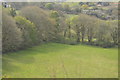
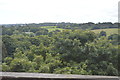
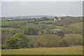
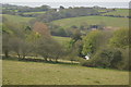
This page details the photographs taken nearby to Jollys Bottom, TR4 8PB by members of the Geograph project.
The Geograph project started in 2005 with the aim of publishing, organising and preserving representative images for every square kilometre of Great Britain, Ireland and the Isle of Man.

There are currently over 7.5m images from over14,400 individuals and you can help contribute to the project by visiting https://www.geograph.org.uk
Image Map
Images are licensed for reuse under creativecommons.org/licenses/by-sa/2.0
Notes
- Clicking on the map will re-center to the selected point.
- The higher the marker number, the further away the image location is from the centre of the postcode.
Image Listing (7 Images Found)
Images are licensed for reuse under creativecommons.org/licenses/by-sa/2.0
Image
Details
Distance
5
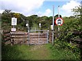
Byway crossing above Jolly's Bottom
Byway 301/7/1 crosses the Image This is presumably a BOAT (Byway Open to All Traffic) , as the notices imply that motor vehicles can use the rest of the byway, but are not permitted to cross the railway here.
Image: © Derek Harper
Taken: 18 May 2009
0.13 miles
7
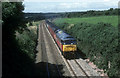
Mail train between Chacewater and Truro
Once there were plenty of mail trains on the Cornish main line here the lunchtime departure from Penzance is seen near Jolly Bottom, next stop will be Truro. There are no mail trains at all in the West Country now all mail travels by road or air.
Image: © roger geach
Taken: 3 Aug 1993
0.25 miles