IMAGES TAKEN NEAR TO
Chacewater, TRURO, TR4 8LZ
Introduction
This page details the photographs taken nearby to TR4 8LZ by members of the Geograph project.
The Geograph project started in 2005 with the aim of publishing, organising and preserving representative images for every square kilometre of Great Britain, Ireland and the Isle of Man.

There are currently over 7.5m images from over14,400 individuals and you can help contribute to the project by visiting https://www.geograph.org.uk
Image Map
Images are licensed for reuse under creativecommons.org/licenses/by-sa/2.0
Notes
- Clicking on the map will re-center to the selected point.
- The higher the marker number, the further away the image location is from the centre of the postcode.
Image Listing (10 Images Found)
Images are licensed for reuse under creativecommons.org/licenses/by-sa/2.0
Image
Details
Distance
2
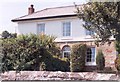
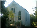
Exmouth House, Chacewater
The house stands on The Terrace about 600 yards from the ruined engine house of the old Wheal Busy copper mine. Exmouth House was built around an original two-room cottage in about 1870 by the Harveys, a notable Chacewater mining family, for Samuel Harvey’s widow Philippa née Pellew (1807-86). She was the daughter of a past Captain of the mine, Israel Pellew, and a relative of a famous Cornishman, Admiral Edward Pellew, Lord Exmouth http://books.google.co.uk/books?id=2_ZstVBZSfIC&lpg=PP1&pg=PA80#v=onepage&q=&f=true , after whom she named the house. It was sold by her granddaughter sometime after 1902. Wheal Busy mine finally closed in 1920.
The fully illustrated story of the Chacewater Harveys is at http://books.google.com/books?id=I-7-V1TJ1jIC&lpg=PP1&dq=A%20Cornish%20Inheritance&pg=PP1#v=onepage&q=&f=true
Image: © D Gore
Taken: Unknown
0.11 miles
4
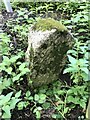
Old Boundary Marker on the former A390
Mine Boundary Marker on the south side of a minor road. Formerly the A390, between Scorrier and Chacewater, immediately west of the junction with High Street, Chacewater parish. Inscribed 6 W / B 1.
Milestone Society National ID: CW_CHACE02em
Image: © P Barnett
Taken: 17 Jul 2023
0.19 miles
5
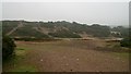
Brunton Calciner
(The landscape to the immediate east of the Brunton Calciner on the Wheal Busy site)
Image : Previous -- (6 of 6) -- Next : Image
This damaged heathland can be viewed from Image
William Brunton patented his ‘Brunton Calciner’ in 1829 and greatly enhanced the speed at which arsenic (an impurity) could be removed from ore. Where the arsenic contamination was high it became economic to recover the arsenic as a by-product.
For an explanation of the Brunton Calciner visit this page from Chycor Cornwall: http://www.chycor.co.uk/tourism/tolgus/page5.htm
For more information view this PDF (4.28mb) from Cornwall County Council, http://212.104.147.54/media/pdf/0/0/CCC_1.pdf
Image: © Alan Walker
Taken: 15 Jul 2007
0.20 miles
7
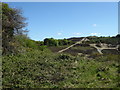
Broken landscape near Wheal Busy
The positions and view direction are a best guess because this worked over former mining land tends to look similar from different positions. I would happily accept suggestions to improve the accuracy
Image: © Chris Allen
Taken: 14 May 2018
0.21 miles
8
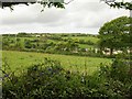
Valley west of Chacewater
A view from near Anzac Cottage on bridleway 301/49/3 across the western edge of Chacewater to the slopes below Wheal Busy. The farm on the hillside is ... "Hillside".
Image: © Derek Harper
Taken: 18 May 2009
0.22 miles
9
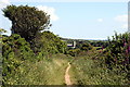
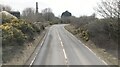
Bridleway to Chacewater
Breasting the hilltop to the north of Chacewater the church tower is the first you see of the village.
Image: © Tony Atkin
Taken: 7 Jun 2008
0.22 miles
10
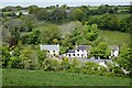
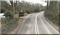
Pasture and houses, Chacewater
Houses on the western end of The Terrace are seen below Primrose Farm.
Image: © Andrew Smith
Taken: 7 May 2022
0.24 miles