IMAGES TAKEN NEAR TO
Kerley, TRURO, TR4 8LH
Introduction
This page details the photographs taken nearby to Kerley, TR4 8LH by members of the Geograph project.
The Geograph project started in 2005 with the aim of publishing, organising and preserving representative images for every square kilometre of Great Britain, Ireland and the Isle of Man.

There are currently over 7.5m images from over14,400 individuals and you can help contribute to the project by visiting https://www.geograph.org.uk
Image Map
Images are licensed for reuse under creativecommons.org/licenses/by-sa/2.0
Notes
- Clicking on the map will re-center to the selected point.
- The higher the marker number, the further away the image location is from the centre of the postcode.
Image Listing (4 Images Found)
Images are licensed for reuse under creativecommons.org/licenses/by-sa/2.0
Image
Details
Distance
1
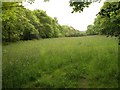
Meadow, Chacewood
Seen from bridleway 301/35/2 as it meets the lane from Chacewater to Twelveheads. The Carnon River runs along the left side of this meadow.
Image: © Derek Harper
Taken: 18 May 2009
0.21 miles
2
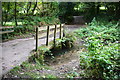
Chacewood Ford
This ford is found beside the bridge at Chacewood.
Image: © John Walton
Taken: 23 Sep 2015
0.22 miles
3
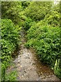
Carnon River near Coosehecca
The site of an old ford where bridleway 301/35/2 from Kerley Hill crosses the stream. Looking upstream.
Image: © Derek Harper
Taken: 18 May 2009
0.22 miles
4
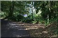
Junction between the minor road and the public bridleway
The public bridleway goes off to the right and Lower Chacewood Cottage can be seen through the trees, see also Image
Image: © Elizabeth Scott
Taken: 3 Oct 2023
0.25 miles