IMAGES TAKEN NEAR TO
Four Burrows, TRURO, TR4 8JB
Introduction
This page details the photographs taken nearby to Four Burrows, TR4 8JB by members of the Geograph project.
The Geograph project started in 2005 with the aim of publishing, organising and preserving representative images for every square kilometre of Great Britain, Ireland and the Isle of Man.

There are currently over 7.5m images from over14,400 individuals and you can help contribute to the project by visiting https://www.geograph.org.uk
Image Map
Images are licensed for reuse under creativecommons.org/licenses/by-sa/2.0
Notes
- Clicking on the map will re-center to the selected point.
- The higher the marker number, the further away the image location is from the centre of the postcode.
Image Listing (6 Images Found)
Images are licensed for reuse under creativecommons.org/licenses/by-sa/2.0
Image
Details
Distance
1
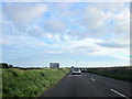
Kenwyn : The A30
Heading along the A30.
Image: © Lewis Clarke
Taken: 2 Oct 2022
0.04 miles
2
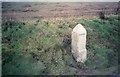
Old Milestone by the A30, south west of Fourburrow Farm
Stone post (plate lost) by the A30, in parish of PERRANZABULOE (CARRICK District), Treissome, Four Burrow Farm, by the road, on North side of road. Erected by the parish in the 18th century.
Inscription once read:-
: (Redruth / 5½) : : (Lands End / 33) :
Grade II Listed. List Entry Number: 1136763
https://historicengland.org.uk/listing/the-list/list-entry/1136763
Milestone Society National ID: CW_PZBM23.
Image: © Ian Thompson
Taken: 1 Jan 1997
0.10 miles
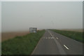
3
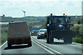
The A30
A vehicle designed to give way to!
Image: © Robert Ashby
Taken: 18 Aug 2014
0.15 miles
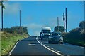
4
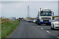
On the A3075
A severe tailback coming from the direction of Newquay.
Image: © Robert Ashby
Taken: 18 Aug 2014
0.17 miles